Author Archives: lt

Philosophy Told in Marfa

cropped-header3.jpg

I’m into words…very into words.  I study them, I distinguish them, I revel in them.  But the truth is, I use too many words.  When I talk, I say too many words.  When I write, I write too many words.  Sometimes even, when I think, I find myself thinking in too many words.  I work too hard to choose words carefully, to express ideas precisely and comprehensively to other people, and occasionally to myself.  In talking to my friend Whitney over dinner last night (you’ve actually seen her before, in Easter Island, Day Two), I told her that I use so many words probably because I am philosophical about things.  That’s wasn’t an excuse, but rather me trying to rationalize, to understand.  I wondered aloud (using words, of course) whether a person could philosophize without words—whether one could use pictures, perhaps, to express beliefs and values and meanings behind things.

Then walking around Marfa today (as I am writing this, that is), I realized that when I look at things, I actually see them and take in their attitude and their setting, often deeply, long before I even think about putting words to the scene.  And the overall images and details that stay with me, because they make a lasting impressing, or because I take a picture of them, maybe do represent my essential point of view: what I truly believe is elemental or consequential or illuminating.

So, I’m going to give it a try.  What follows is what I feel means things and explains things and reveals things and asks questions about things.  My camera is my pen, and the pixels are the words, at least for today.

This slideshow requires JavaScript.

Ayers Rock (Palya, Uluṟu)

cropped-dscf1752-1280x9602.jpg

Flying into Australia was a little intimidating. Rules, rules rules. Rules about what you can bring, and what you can’t. Rules about how to declare what you can bring, and how to declare what you can’t. Rules about what will happen to items you can bring, and what will happen to items you can’t. Et cetera. They also announced that we would have to take everything off the plane and bring it through customs, which was fine for me and Mom (we only had to additionally bring our “bagalini”), but for a few of the big shoppers it meant having to lug several additional bags stuffed with…well, stuff (good stuff, mostly from Peru). Much grumbling and griping. And lugging, for some.

We must have lined up 5 or 6 different places getting through customs and immigration in Brisbane. It was a hassle, but we got through okay with our regular luggage and our bagalinis (which incidentally, seems like a double-plural to me—I think it should be bagalino/bagalini, not bagalini/bagalinis). Not so fun for others, some who were forced to open multiple bags (in one or more of the 5 or 6 processing lines), or redistribute stuff between bags (camera lenses, etc.) to get under the 7 kilo per-bag carry-on limit (another rule that we never actually saw anywhere in the dissertation that was the rules publication).

After getting back to the gate for departure to Ayers Rock, Mom and I found an aboriginal art and crafts shop in the terminal. It was run by an organization that provides paint and materials to aboriginal artists, sells their works, and gives them back some of the proceeds. I had a couple of interesting small paintings (on unstretched canvas) in my hands, but time was short, and I ended up not buying because I didn’t want to make an impulse buy. It turned out to be the best opportunity in our visit to Australia to get a few works that I liked, and I missed it. Oh, well…

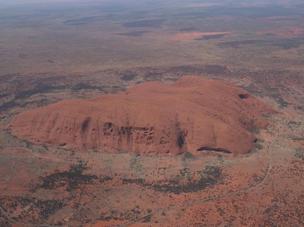
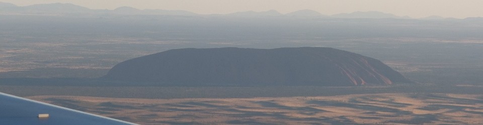
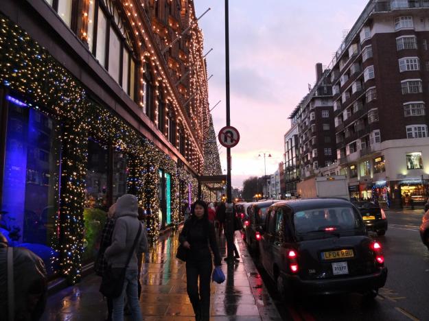
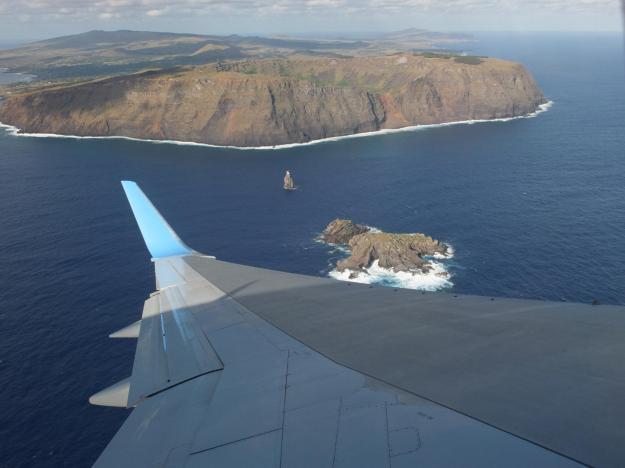
Back on the plane for a three hour flight to Ayers Rock, landing on just a tiny strip of runway in the desert. To call it an airport would be a big stretch. Beautiful smooth touchdown and braking by Captain Jon (apparently, Bravo Fox is specially equipped for such landings, with engines capable of massive thrust reversal and 8 brakes, which apparently is a lot). More on Captain Jon’s awesomeness at the end of this post. Anyway, the sun was getting low as we landed, see headliner photo (which is also serving double-duty as a teaser for Uluṟu photos to come).

Note that “Uluṟu”, which you all must know by now is the aboriginal name for Ayers Rock, is pronounced with the accent on the third syllable (“ṟu”), similar to kangaroo or Timbuktu, and not like micro-brew (first syllable) or tonkatsu (second syllable). Of course, that’s only when enlightened white Aussies say it (for instance, to a bunch of unenlightened tourists). When the Anangu (A’-na-nu) use it in a sentence, none of us born without a boomerang in-hand can possibly parse out a single syllable of any kind, let alone know where the freaking accent is.

The next morning, before getting anywhere near Uluṟu, we took a trip to The Olgas, which is a nearby rock formation whose Anangu name is Kata Tjuṯa (pronounced by our Aussie friends as “ka-da-JU-da”, adopting your thickest possible Crocodile Dundee accent when you say it—who knows what the real pronunciation is). They are actually part of the same national park, as apportioned by the Australian government. Here is a view of “the dunes”, which is the rock profile flanking the four Olga rocks themselves (only two of which can be seen as the left-most outcropping; the other two are hidden behind it).

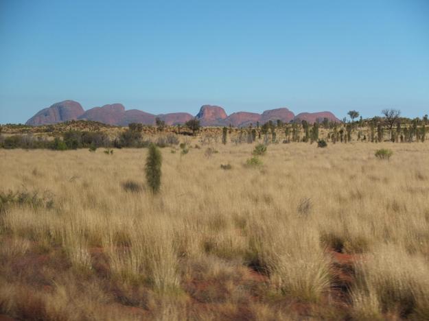
Note that in the Anangu language, “Kata Tjuṯa” means “many heads”, which may actually include the “dune” rocks (not counted as Aussie “Olgas”)—in which case, there would be a clear conceptual misalignment, representative of the inherent cultural incompatibility between conqueror and vanquished everywhere (until the vanquished are actually just vanished).

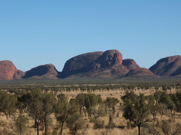
Here is a closer view from a slightly different angle in which all four of the Olgas (though fewer of the many heads) are visible:

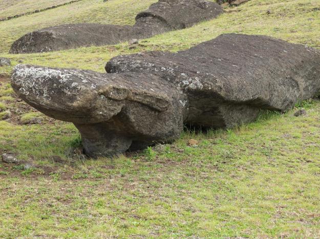
And here’s a view from the same spot of one of the many heads (not an Olga), which actually looks like a tortoise to me:

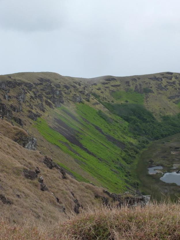
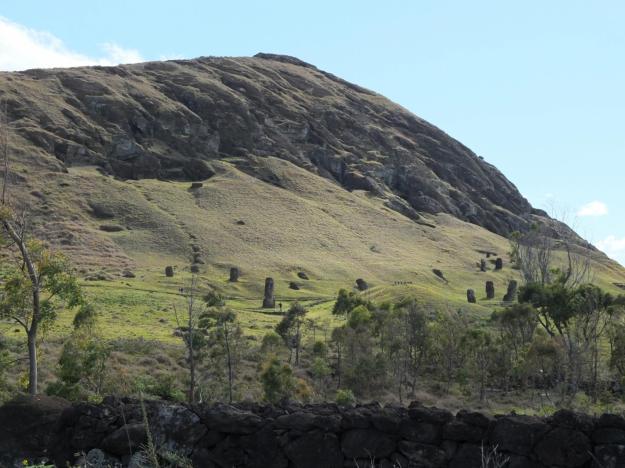
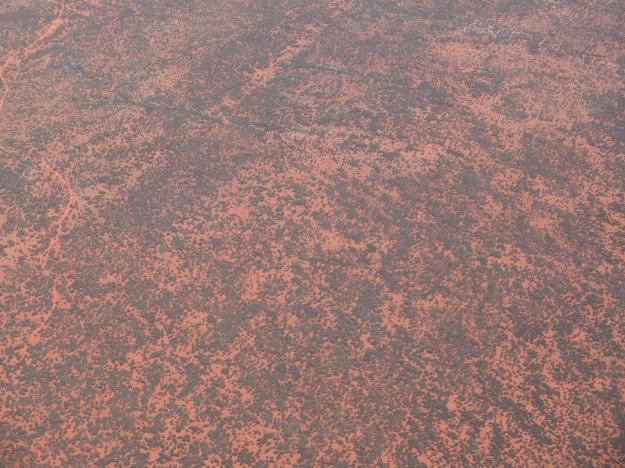
One thing that I really loved about the Australian outback where we were, was just the bush (how’s that for four W’s in a row?). Sometimes it was diverse in composition, sometime very uniform (as here), but it always seemed tranquil and timeless, and always represented hardiness to me, since it is just implausible that anything green could even grow out here. The wonder of the bush continues when you see areas scorched by wildfire, only to be reborn from the ashes. We saw bush in all phases of life and reincarnation, even in just this limited visit. I’ll show you an aerial view later, and explain why it is significant.

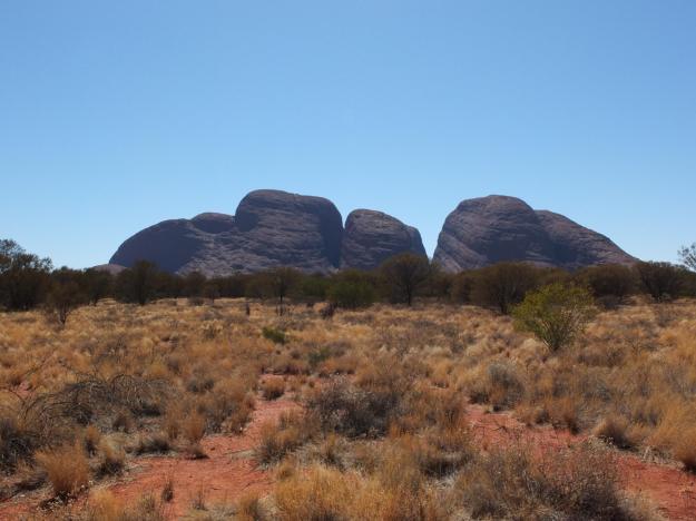
We came around to the backside (west side) of the Olgas. Here you can see all four of them (in white-people accounting, that is):

From there, we took a hike up the Walpa Gorge, between the southern two Olgas (right hand side, in the previous picture). Here is a shot of Olga number two, looking back out toward the mouth of the gorge:

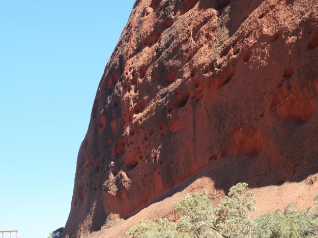
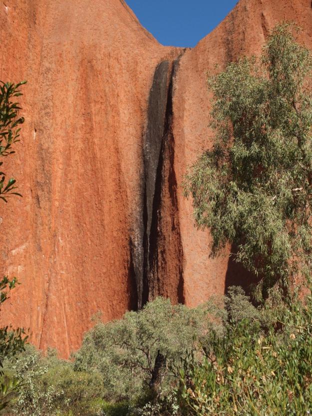
All of the pits and grooves and surface features are naturally produced by wind and water erosion, and the vertical black streaks are lichen and other plant matter that remain when waterfalls, formed by the few yearly torrential downpours, dry up. You will see more of these waterfall residuals in pictures of Uluṟu.

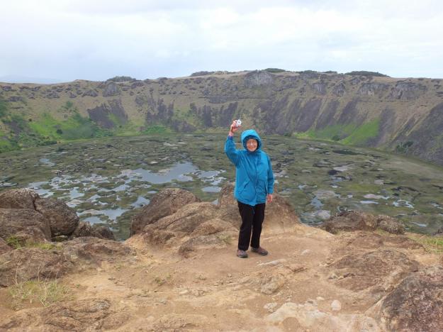
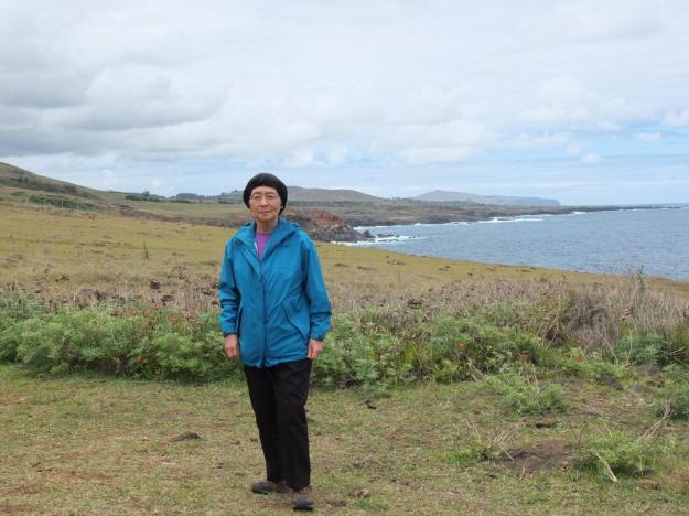
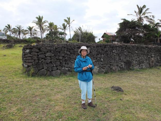
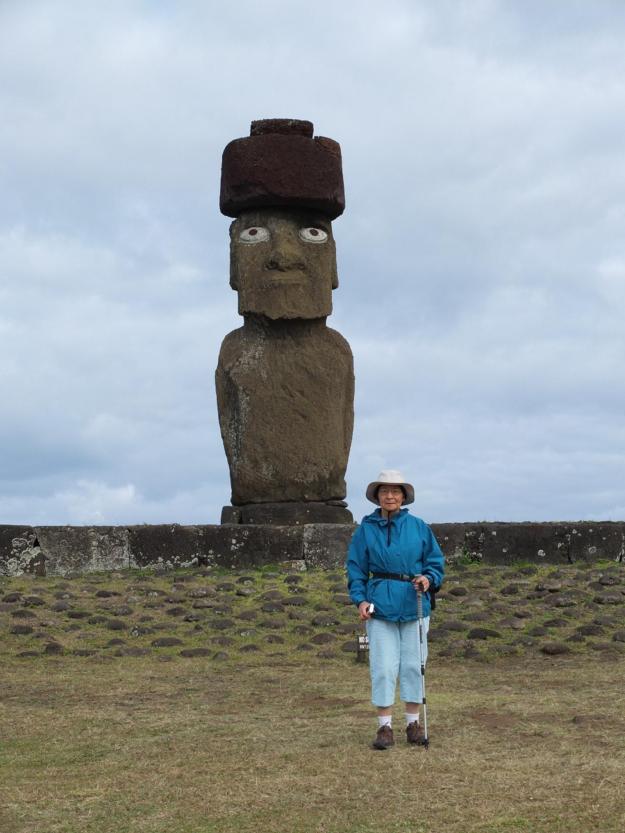
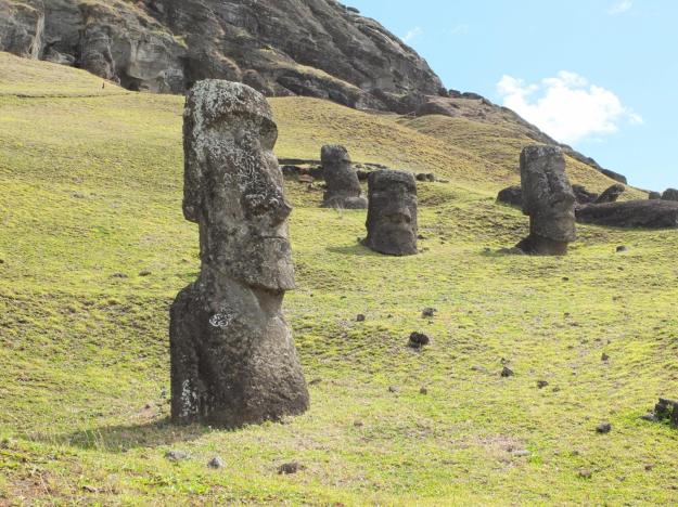
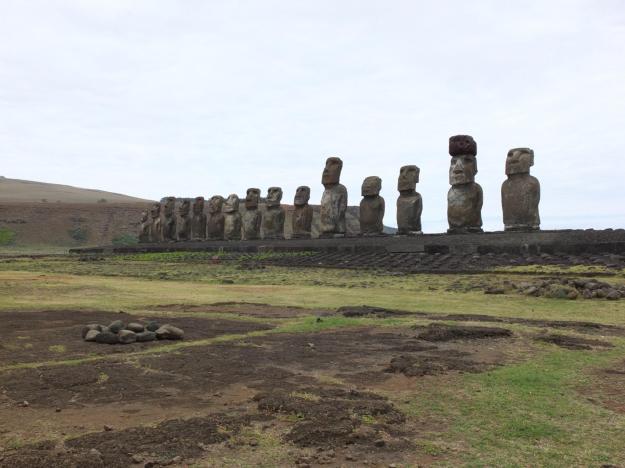
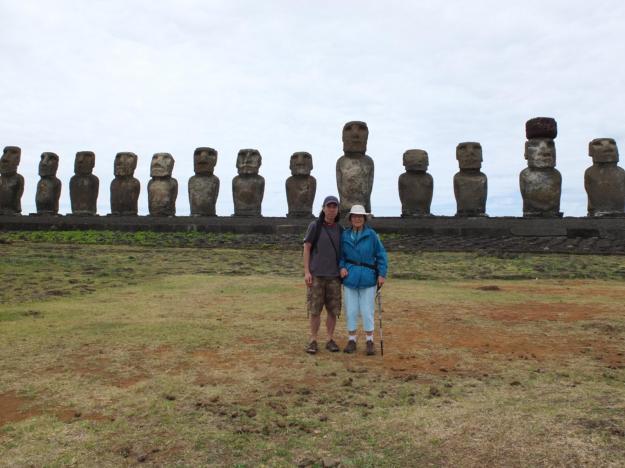
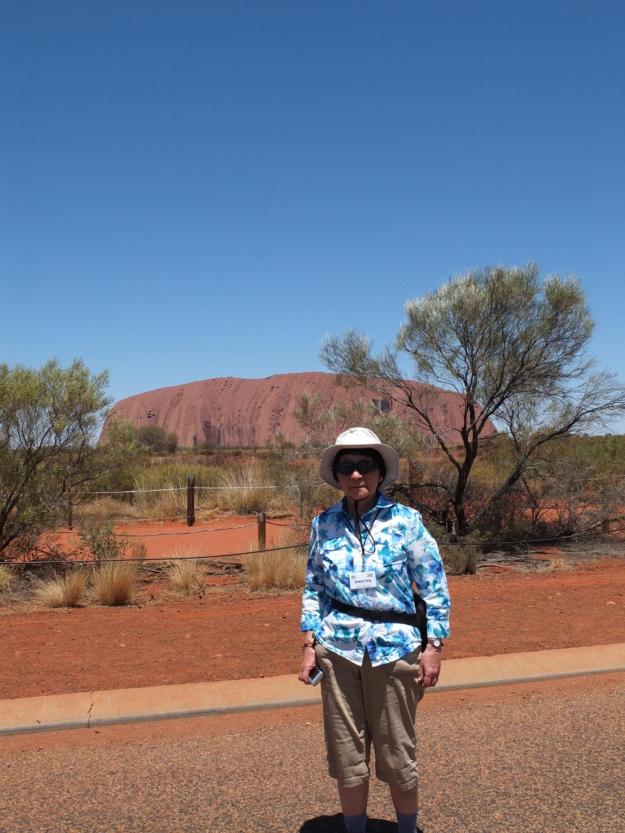
Speaking of Uluṟu, here’s Mom in a photo op, on our way to visit the big rock after lunch:

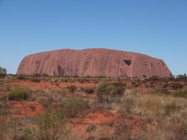
Here is a closer view, framed by more of the awesome outback bush:

We took a driving tour most of the way around the rock. The driver and guide (which are one and the same in Australia, the only such place during our trip, most likely because driving is reasonably civilized in Australia, and not a continually harrowing and life-threatening affair as in the other places we visited) explained to us that there were male and female “places” (meaning sacred places) around Uluṟu, where male and female activities were practiced. Not only are males not allowed to go to female places (and vice versa), the Anangu don’t even talk about their places and activities across genders. Many of the most interesting features around the rock—mostly caves and other sheltered areas—were such sacred places, either male or female, and the guide asked us not to take pictures of them out of respect for their culture. During this drive-around, the on-again/off-again picture-taking directives seemed rather forced and disingenuous, as if to inject some overblown reverence into the overall locale out of white man’s faux-remorse for invading and co-opting their most treasured territory, and relegating their sacred traditions to tourist attractions (rather than actually reverse the intrusion, and give them back their place and their ways). “This is a female place, no pictures…okay, now you can take pictures…male place, no pictures…okay, pictures…not now…now okay…”—it grew tiresome fast. Only later in the afternoon, after spending some time in the cultural center, and being led on a walk by Valerie (an Anangu guide), did I begin to understand how the concepts of sacred places and activities were related to the interdiction against photographs. I’ll get to that shortly.

First, the cultural center. We weren’t allowed to take picture inside there either. This seemed like more of the overblown reverence to me. I had wanted to try and buy an aboriginal painting (though it’s not as if I have any lack of stuff to hang, given all of the framed prints sitting on the floor stacked against the wall in my house), after getting hooked by the smaller pieces at the Brisbane airport. The iconic dot paintings that depict animals and people (at least their butts, represented by U-shaped lines) and specific surface features, like rivers and water holes, don’t really do it for me. They’re too primitive, in a crafts-project kind of way, for me and my snooty post-Renaissance western-European sense of aesthetics. The ones I like are more abstract, and represent the overall texture of a landscape, or even just a concept (such as dancing) without any discernable pictorial mapping. I hate to say it, but they’re just more western looking.

Painting is actually a somewhat-recently acquired art form for the aborigines, with the introduction of modern canvas and paint by westerners fifty or so years ago, though many of the designs and symbols they use are not only traditional but downright ancient. It also seems like some of the abstract expressions that I responded to were only brought about with aboriginal exposure to airplane travel and viewing the land from above (or possibly, photos from above), unless the artists are truly able to envision the larger texture of the land purely based on their ground-level experiences of the land. Though none of the paintings looked anything like this (or any other aerial shot) in explicit terms, some of them had an incredible similarity of emotional quality.

I saw several paintings, generally large, that I was considering buying—or at least, thought I was considering buying—, but there really was not enough time to fully absorb the images and decide whether I would actually want to hang them. Too bad I can’t show pictures of them, but I honored the request not to photograph. In the end, I wasn’t sure whether I loved any of the paintings more than I actually just loved the idea of buying a painting (and it wasn’t so much about whether to spend $1000+ on one, since I really did intend to support the aboriginal community in some way, after Brisbane), so I did the cowardly (and wise) thing and walked away with regret.

One of the canvases I really liked was meant to depict a women’s ceremonial dance. But because the artist did not want to reveal things that were private to women and private to her people, she chose to make it a purely abstract representation, with verticals lines of red and white and blue and black, with jagged edges and a very tribal feel. It showed nothing of the ceremony (that I could see), but must have been her way of conveying a spiritual essence of it. This was a lesson in the sanctity of their knowledge and their ways that I was able to personalize. This jealous protection of their secrets humbled me, and I had to accept my alienation from it.

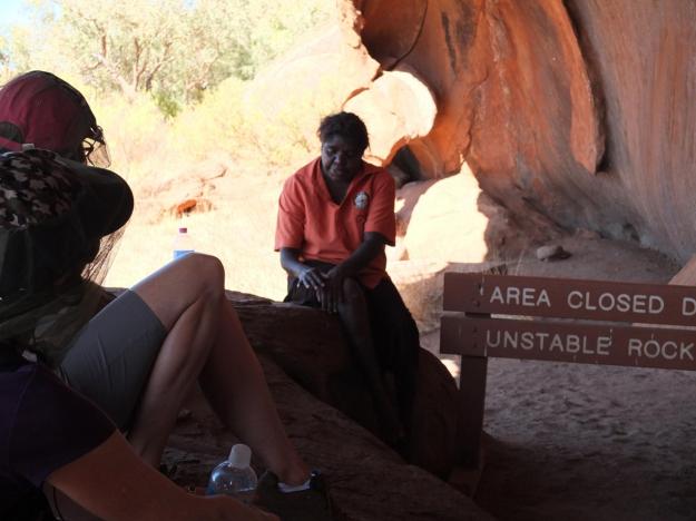
After the cultural center, we went on the Mala Walking Tour with Valerie and John, a white Australian guide who acted as translator. As we walked along a trail at the base of the rock, Valerie told the story of how the Anangu people came to this area, speaking in an unparseable mumble, which John appeared to actually translate (as opposed to just telling the story his way in English). This whole act of mumble-translate-mumble-translate started out feeling very staged and awkward to me (John said she was very shy), but at some point, Valerie seemed to loosen up and deviate from a purely rote narration, and the interaction between Valerie and John (and by extension, us) became easier and more interesting.

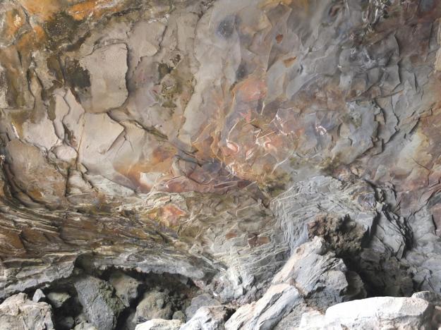
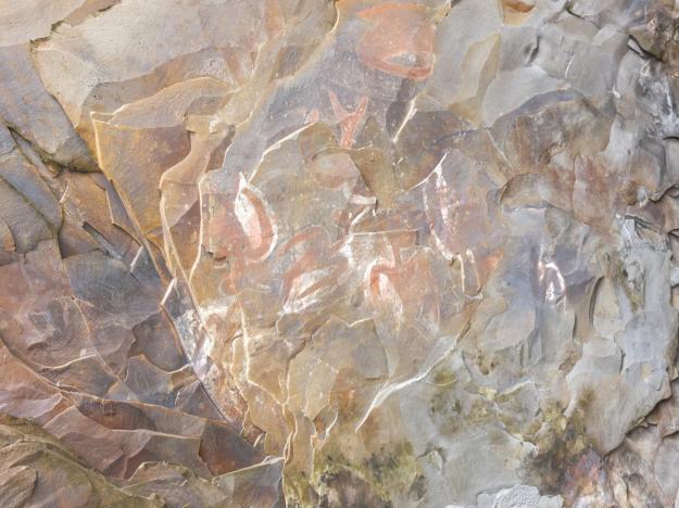
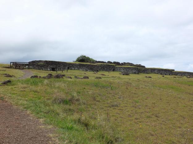
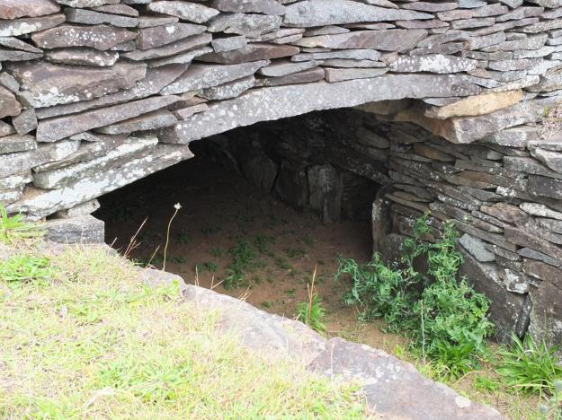
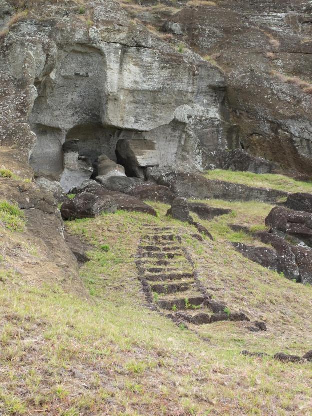
Valerie showed us a number of caves, some of which were too sacred for pictures, but some not. Each one had a story and a place in the history of the Anangu people.

In one of the caves, some of the Anangu ancestors were trapped by a beast, and ended up frozen in the walls. These ancestors protect the current Anangu people when they use the cave now.

In another cave, Valerie showed us what appear to be primitive drawings.

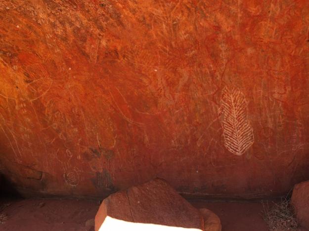
It actually turns out that this is actually not art, but knowledge passed down from grandfather to grandson (by the way, I’m a little fuzzy on how Valerie was able to show us this place, since it is a male place). The elder communicates the knowledge when the time is right, and in the way that is right, and the youth accepts it as presented, without questioning. This is also the manner in which Valerie recounted the Mala story to us (with the help of only John’s voice).

At one point, we passed another walking group, who said that they had just seen a wallaby nearby. Valerie said, with great assurance—even without having seen the animal—that it was there because of the water hole. We saw no signs of water or moisture anywhere about—it was 100 degrees out and totally parched. She took us to a sheltered area with a steep sandy floor and told us to watch (though, no pictures). She took a short rugged stick and started digging in the sand at the base of the rock. She dug purposefully and with a clear technique, and after about five minutes, the sand became moist. She kept digging, with a different motion and a slower rhythm, and soon water started pooling the hole. She cupped with water in her hand and splashed it on the wall to show us it was real, and the pool refilled itself as she scooped out each handful.

As I have been alluding to, the Anangu generally view photographs of themselves and their sacred places and activities as taking away from their spirit, but Valerie told John to tell us that it was okay to take pictures of her, but not too many. I shot this one surreptitiously, so as to take away as little of her sprit as possible.

There was one other interesting interaction at the water hole. After Valerie found the water for us, John had a brief exchange with her, and then she walked a little distance away. John told us of how the Anangu men would hunt animals who can to drink at the water hole, taking only what they needed, and the technique for assuring that the animals would return. I asked John if he had to ask Valerie’s permission to tell the story (which is what it seemed), and he said yes. Interestingly, I think she allowed him to tell it (and not tell it herself) because she felt it was his knowledge to impart, his story to tell. To me, this sequence said a lot about the rigidity of the gender roles, as well as her acknowledgement of his acquired acceptance by her people and belongingness the land. Note that John had to learn the language and the ways by living within the Anangu community, there are no classes or lessons or other ways to acquire the knowledge.

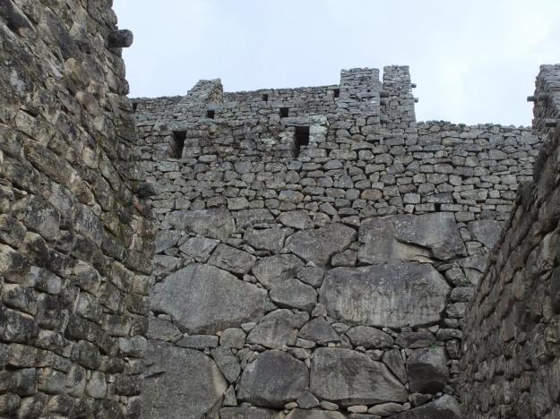
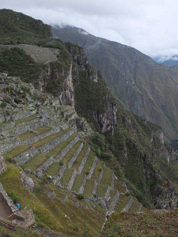
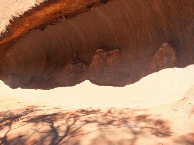
During the walk, it was also extremely interesting to get a closer look at the rock surface, which was actually fairly rough and abrasive, but very regular (it is said that it you fall from the top, you will be skinned alive before being killed by the impact).

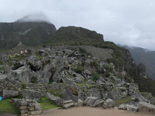
As with the Kata Tjuṯa formations, Uluṟu exhibited a number of areas where water runs down following large storms and leaves traces of plant material.

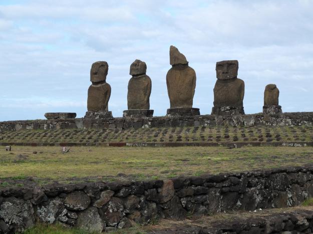
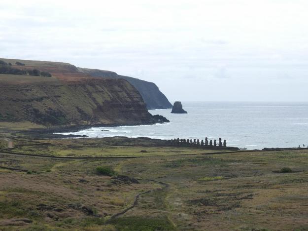
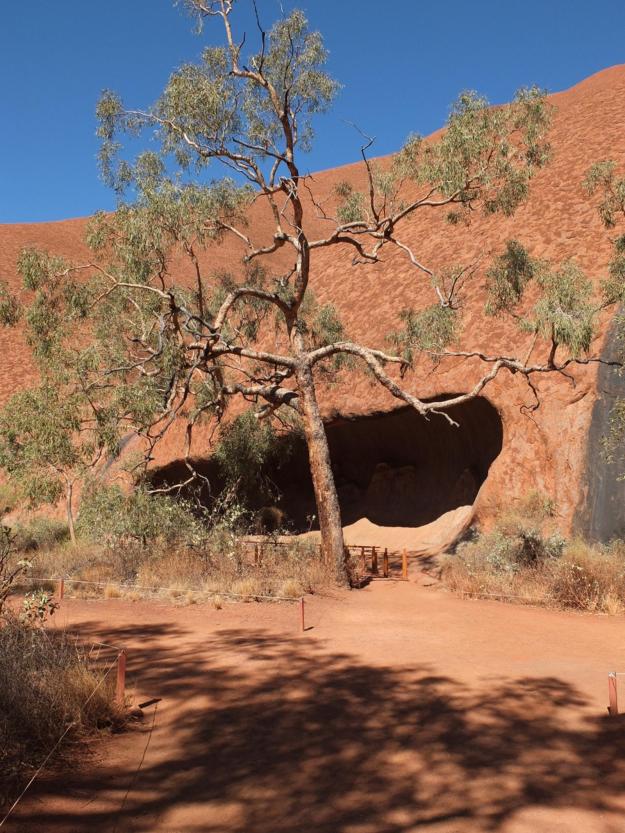
Note the presence of many smaller caves and areas of shelter in these last two photos, as well. Uluṟu, the rock, is indeed awe-inspiring from any angle and any distance, the entirety of it as well as all of its special and secret places.

One last shot from the Mala walk: can you imagine what this would look like after a big rain?

At the end of the tour, we said “Palya” to Valerie, which means “thank you”, but also “hello” and “good bye” and “peace” and “good wishes” in general—much as “Aloha” in Hawaiian or “Shalom” in Hebrew. I mentioned to a fellow member of the tour that we Americans don’t really have a word for such a simple and beautiful—and perhaps, ancient—concept; that we’re basically too damned literal in what we say. She suggested, “how about ‘peace be with you’?”, but I don’t think that’s quite it. First of all, it’s really only used in church, and second of all, it doesn’t really convey all of the meanings. Perhaps closer is just “peace”, at least as it was used by hippies during the 60’s, but not anymore. Now it seems to be more prevalent as a defensive measure, like “don’t taze me, bro”.

That night, we were treated to a “Sounds of Silence” dinner out in the desert, which featured champagne and cocktails on a little plateau looking out at a gorgeous view of Ayers Rock at sunset, dinner accompanied by a didgeridoo and about a billion-and-a-half grotesque and dim-witted flying insects attracted to the table lights, and a post-dinner tour of the clear and moonless southern sky. Very easy to see unaided, and totally awesome, were an upside down Orion, the Pleiades, the Orion Nebula, Alpha Centauri, and both the large and small Magellanic Clouds, among a host of other glowing objects.

Some of us also woke up at 3:30 the next morning to see the early morning sky, before heading out in a larger group to catch at sunrise at Uluṟu. Everybody’s favorite is of course the Southern Cross (really just called “Crux”, or “The Cross”), but Alpha Centauri (our closest neighbor at 4.3 light years away) was also still prominent as the lower of the two stars in the bottom of this picture (sorry for the crappy photograph, I had neither a tripod nor a clue as to how to shoot stars).

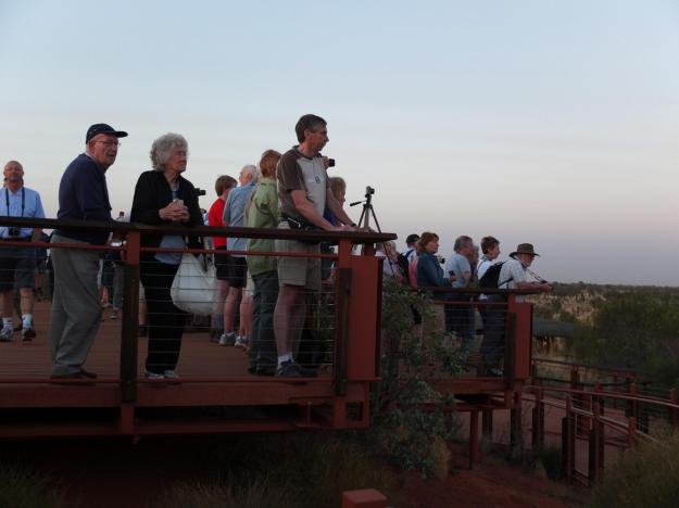
The scene at the sunrise viewing location was quite a circus. Apparently, this is a very popular thing to do, there were many, many tour buses out there before the dawn, each with a hastily erected table with coffee and pastries. The viewing platform looked like this:

Here’s the pre-dawn light silhouetting the clever and stalwart desert trees (more shots of them in the light, below):

Note the sliver of a moon; this was just two days before the total solar eclipse that we were scheduled to see in Port Douglas.

And here’s the actual sunrise through the bush:

It was actually a little hazy that morning, so we didn’t get the classic rich red ochre Ayers Rock shot that you see in the calendars. Some of the people were disappointed, but seriously, you can’t expect to get that every day. Here are two views of the colors and the shadows changing as the sun rose on that particular day:

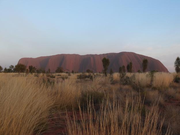
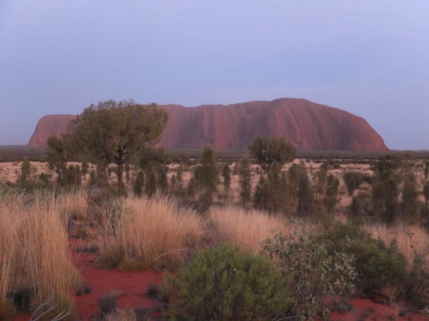
I personally was not disappointed in the least. I saw the conditions and the changing light, both at Uluṟu and at Kata Tjuṯa, as Monet would have: with receptiveness and serenity and wonderment at the uniqueness of the moment.

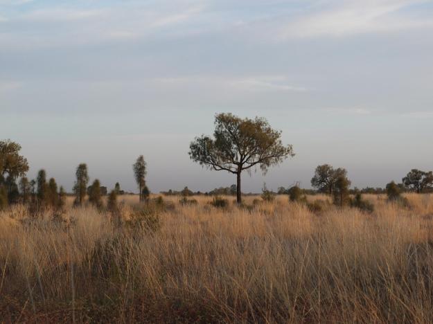
I mentioned the desert trees in the area, I don’t know what species they are, and recall only scant details of their amazing survival techniques, but I do know that they are both distinctive as species, and individual in their looks. If I had time, I would shoot a whole bunch of them and arrange the prints in a grid for display. For now, these two will have to suffice:

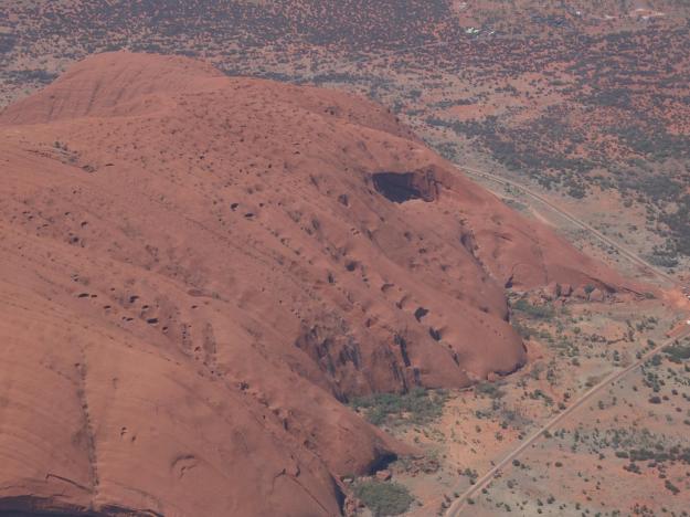
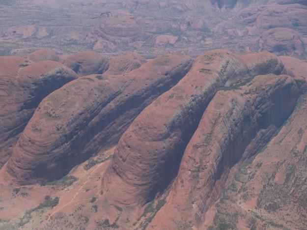
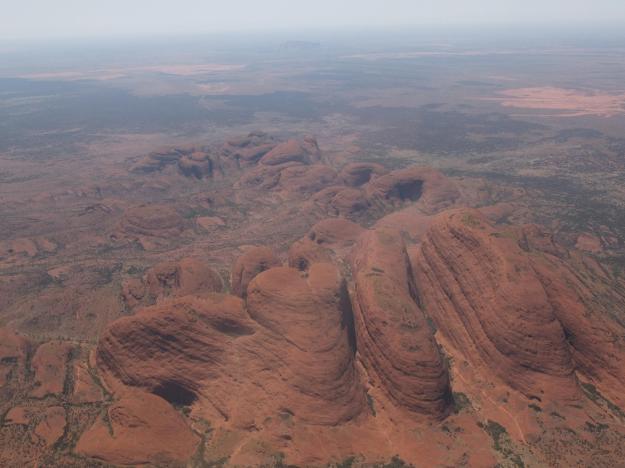
As we flew out of the Ayers Rock area that day, Captain Jon treated us to a low and slow fly-around (6500 feet, at just under 200 miles per hour) of both Uluṟu and Kata Tjuṯa. He circled both rock formations twice, once for each side of the plane. I’ll let the pictures do the talking to close out this post.

A Nice Day in Oxford

Before starting the post on Oxford, here are three things I’ve learned about people in England:

  1. Everyone smokes. Okay, maybe not absolutely everyone, but a hell of a lot of people for sure. Definitely everybody who works for the bus company—and there is at least one of them for every civilian on the street, they all hang around at the bus stops in groups of three or more, doing who-knows-what, and all wearing their high-viz yellow or orange rain jackets (since England has generally low-viz weather, and of the wet variety). And the smokers all smoke incessantly, down to the nub, burnt fingers and all. I’m surprised we don’t see big hunks of lung spewn [yes, “spewn”] about in the streets and gutters, especially near bus stops.
  2. Everyone is sick. Buses, trains, restaurants, shops, walking in the streets, on bikes, coughing, sniffling, sneezing, nose blowing, sounds of phlegm and mucus…yecch.
  3. People have no idea which side of the walkway (sidewalk or any other footway) to walk on. Cars drive on the left side of the street, so you would expect that to be the pattern for foot traffic as well (no matter how wrong it might be—after all, your sword hand doesn’t change). But there are signs directing you to the right side of the staircase entering or exiting Tube stations, as well as to “stand on the right, walk on the left” on escalators (as is normal for us). So what do people in England do? Some people walk on the left side of the walkway, and some people walk on the right side of the walkway—and I mean Brits, not just clueless Americans and French (and not even Brits hoping to avoid running head-on into clueless Americans and French). And the Brits walking down the left side of the walkway do so resolutely, you cannot scare them off-line in a game of sidewalk chicken (they run smack into you deliberately, then smirkingly mutter, “sorry”). And the Brits walking down the right side of the walkway do so resolutely as well (“sorry”). It all makes not a bit of sense.

Now that I’ve gotten that out of my system, here we are at Paddington Station, wheelie bags in tow.

Mom is wheeling mine to safety, as I stand, back to traffic, taking the picture—not that I would know which direction to look for buses trying to run me over anyway.

After a one-hour train ride (“smooth as the sail of a gull”), we ended up in cold and windy Oxford. Very windy, like 30-miles-per-hour windy (that’s miles per hour, not no puny little kilometers per hour). Anyway, it was way too windy to enjoy any kind of college visiting, so we just scurried a little around town, ducking into whatever sheltered locations we could find.

I spotted a painting in a gallery from across the street, which I thought was Mackenzie Thorpe, so we decided to go check it out (that is, get out of the cold and the wind). It actually turned out to be an artist named Doug Hyde, whose work is insanely virtually identical to Mackenzie Thorpe (deviating only by the slightest parallel universe). The gallery owner, who I chatted it up with, told me that they stopped carrying Mackenzie when he started going really dark in about 2006, and assured me that Doug Hyde was now definitely the most popular artist in Britain. Personally, I like Mackenzie’s dark stuff (some of that big-heart stuff I could do without). Upon leaving the gallery, I was shocked to see these Doug Hydes in the window:

For those who don’t know, these are quantum clones of Thorpe sculptures (forgive my terrible pseudo-physics qualifiers, clearly I know they are gibberish). The art world is nuts.

We also visited the Covered Market, where there are a number of junky knickknack shops, some decent-looking small cafes, and a few amazing specialty food stores, this being one of them (and by the way, it was Thanksgiving—not that they give a hoot about it over here):

We then headed to Cornmarket Street, which has a promising-sounding name and is wide and pedestrian-only (which means welcome relief from the throngs of Oxford double-decker buses, and hence the throngs of chain-smoking bus line employees in high-viz yellow and orange), but unfortunately the street has nothing to boast for its seeming advantages. Instead, it is the home of Starbuck’s, McDonald’s, Burger King, KFC, and The Gap. No kidding.

This was the one-and-only time we walked down this terrible block of Cornmarket Street (between High and Broad Streets), which, by the way, also hosts Oxford’s oldest building, Saxon Tower (who must be pretty pissed about its crappy new neighbors).

Since we had only a light breakfast in London before getting on the train, Mom was hungry for a fairly early lunch, and we stopped in at The White Horse for some authentic pub food.

This is one of the oldest pubs in Oxford (licensed in 1591), and is actually tucked between the two entrances of a bookstore (Blackwell’s). It is awesomely small and cramped on the inside. Mom and I sat at the table under “The White Horse” photograph. Whoever that is on the white horse, indulging in the great adulation of the masses (either that, or fending them off with a broken sword), we have no idea.

That’s “game pie”, with duck, pheasant, quail, and venison, in front of my spot. Mom, not being as game (so to speak), opted for the carrot and coriander soup. Incidentally, we have also found out that she is not so game for black pudding or mince pie in England either. The matriarch of the tavern wouldn’t let us leave without trying the apple crumble, drowned with piping hot custard, for desert. It was actually quite good, and we stumbled out of there, battled the wind back to the hotel, and passed out for a few hours. After that, we lounged in the hotel lounge, had dinner, then back to sleep. The rain came down and the wind was blowing up a storm.

That was not actually the nice day in Oxford promised by the title of this post.

The next morning, here was the view out of our hotel window:

This was the nice day. Clear and crisp. No rain, no wind, but tons of chill, just to make it interesting (39 degrees when we stepped out of the hotel).

We had breakfast at the Queen’s Lane Coffee House, which boasts of being “the longest established coffee house in Europe (since 1654)”.

This is not to be confused with the Grand Café, directly across the street, which claims to be “the first coffee house in England (in the year 1650)”.

The coffee house turf wars must be nasty. I wonder how many times front windows have been shot out of both establishments.

Anyway, it turned out to be a really beautiful day. We were bundled up (Mom in Smartwool, a down jacket, outerwear, and gloves), so actually the cold did not factor in much. It was sunny and nice out, we almost forgot we were in England. That is, until we saw this:

Yes, folks, that’s the outside of the Great Hall at Christ Church College, rising majestically above the south wall of the college and the lovely English garden in front of it. The Great Hall has now become the top tourist attraction in Oxford because it served as the model for the Great Hall at Hogwarts in the Harry Potter movies. I definitely had mixed feeling about going to visit, since I would rather be motivated by its role in the daily life of a venerated, 466 year-old institution of learning, than its role in a few dozen scenes of a 20-year old 7.7 billion-dollar grossing film series (and note that the hall wasn’t actually used for the filming, but only as the inspiration for some soundstage at Warner Bros. Studios Leavesden). But, actually my ambivalence turned to enthusiasm upon getting close, it was clear that this was an epic thing to see, Harry or no Harry.

Here is a shot looking up at the outside of the foot of the hall (you can match up the turrets with those from the previous photo):

And here is the top of the stairway leading up the entrance of the hall:

Apparently, this (or the steps leading up the landing that I am shooting from) is where Professor McGonagall first welcomed the new students to Hogwarts in the first movie, but regardless, the architecture is stunning.

For those of you who went to MIT, I ask you to compare this with Lobdell, in the old Student Center (opposite 77 Mass Ave.). Close? I think not. Or if you have any doubts whatsoever, try this on for size:

Note that this can’t be where they actually filmed Harry Potter, since there are only three long tables. This could only be Hogwarts in an alternate universe (perhaps the one where Mackenzie Thorpe didn’t go dark, and Doug Hyde worked for the London bus line). Also note the lack of candles floating in mid-air and absence of magic indoor snow. The scaffolding for the non-self-decorating tree is also a dead giveaway.

Behind the high table hangs an imposing standing portrait of King Henry VIII, flanked by smaller (though equally famous) portraits of Queen Elizabeth I and Cardinal Wolsey (you can read about their roles in the founding of Christ Church on Wikipedia).

The proximity of Henry VIII and Cardinal Wolsey is perhaps ironic given the complex and treacherous relationship between the two.

Here is the awesome chapel at Christ Church College, which is replete with memorial plaques (and perhaps inlaid coffins, as well), reminiscent of, but not close in scale to, Westminster Abbey:

To the left side of the alter is a stained glass window dedicated to Saint Cecilia:

In addition to being a lover of music (St. Cecilia being the patron saint of musicians, that’s her accompanied by angels playing a lyre and a viol of some kind—I believe Cecilia herself has a small pipe organ, though I can’t see how it could possibly work, perhaps it’s a quantum organ), some of you may know why I also included this picture.

Three more very nice views of Christ Church College. First, the sundial (one of many within the Oxford colleges) on the side of the Kilcannon building:

Second, the façade of the Meadow Building, through which visitors enter (notice the awesome tree/vine-thing climbing the wall on the left-hand side):

And third, the view of Tom Tower, designed by Christopher Wren (look him up, if you don’t know who he is):

That was our look back at the college as we departed.

We had some more traditional British comfort food for lunch today (what do you know? actually blogging about events on the same day), to combat the cold (though not the rain and wind, which were doubtless visiting some other part of the UK). Shepherd’s pie for me, and soup again for Mom.

I too was disappointed by the tea bag (Twining’s, it was). Here was the hygiene rating posted on the outside of the small shop where we ate:

I, myself, was hoping it would go to eleven (don’t you think visitors deserve a little better than “very good”?).

The other college that I wanted to go visit was New College (founded in 1379—there is a warped sense of time in both Oxford, and England as a whole, that we upstart Americans have a hard time grasping). It just turns out that this and Christ Church are the two colleges whose choirs I have the most CDs of (no, I’m not obsessed with music, or anything). On the way, we passed by the Bodleian Library (which I know nothing about, since they don’t have a college choir); Mom went in to see what the fine was for overdue books.

Here’s Mom doing her Abbey Road impression in front of the Bridge of Sighs at the entrance to New College Lane:

We went down this street for about 15 minutes without finding an entrance to New College, before realizing that it had long since turned into Queen’s Lane (just after the foot-and-a-half wide alleyway leading to the renowned Turf Tavern), and we were now trying to get into Queen’s College. We had to backtrack and go around another way. The entrance is actually on Holywell Street.

Finally inside, here is Mom standing in the New College Gardens (again, lovely English garden, but what else would you expect?):

Take notice of the walls of the garden (which actually turn out to be the old city walls), see how new they are (in keeping with the name of the college)…NOT!!!

Here is the Great Hall at New College:

Perhaps not as great as the one at Christ Church, but at least this can seat four houses of wizards without the risk of cooties.

We were not allowed to take pictures in the chapel of New College, so of course I didn’t.

And here’s a close-up that I also didn’t take:

On our way back to the hotel, we stopped in to visit All Souls College, which has only graduate students. The design of the chapel wall behind the altar is similar to New College, though smaller, and with a different arched arrangement of the figures.

Outside the chapel, shooting from the side of the main quad, you can see the Radcliffe Camera looming over the main gate.

It is very typical in the central colleges of Oxford to see parts of other colleges, or the university buildings, in view, especially the larger, more ornate structures. The colleges now closely abut one another, as the institutions have taken shape and filled the available real estate over 900+ years of development. It is truly an amazing place.

Here is one last view of the university, taken as we returned to the hotel; this is the Examinations Schools building.

On the far left-hand side of the picture, you can see a white building with “Eastgate Hotel” written on it. That’s where we started and ended our very nice day in Oxford.

Cold and Rainy London

This is totally not cool, but I am jumping ahead to London temporarily, will come back to the stops in Australia, Indonesia, India, and Jordan shortly (or sometime thereafter). This is mostly to reassure those of you who have inquired about our well-being (okay, the one of you) that we have made it here in one piece (or make that, two pieces, depending how you count).

I’ll leave the end of the organized trip for later, to be recounted in sequence (no spoilers here), so I’ll pick things up here from after checking in to our new hotel, the Lancaster London, near Lancaster Gate (meaning, gate into Hyde Park). On recommendation from several of the folks on the tour, we decided to get tickets for one of the double-decker tour buses to see the famous sites of central London (makes a round in two to two-and-a-half hours, stupposedly [sic]), then to use the 48-hour ticket as a hop on/hop off pass to get around to the sites we want to actually visit. Big mistake. Or, at least a 50£ ($85) mistake, which I guess in London may not be that bad, a stick of gum isn’t too much less than that. Anyway, after noticing that the Original Tour T2 (red) line bus started deviating from the planned route, I asked the driver, “What the crikey???”, and he informed me that there was a fatal accident in the West End, after which they close the street for the investigation, and the bumper-to-bumper maze-crawling that is normal traffic in central London actually just comes to a halt. Here is our front-row seat view it:

Being stopped in traffic, I was able to snap this beautifully framed, artistic view (some would just say, obstructed view) of Nelson’s Column in Trafalgar Square. Brings memories rushing back of The Giant Alexander (continuing the theme of memorable/haunting childhood books).

We were actually on our way to St. Paul’s Cathedral, which those of you who have been to my house know I have a painting of hanging over my living room mantle (the pride of my meager collection). I also have 25+ recordings of St. Paul’s Cathedral Choir, including the full set of 150 Psalms set to Anglican chant (which I listen to soothe me through troubled times—this is true). I have always wanted to visit. So we did. And it is spectacular.

We didn’t actually do a full visit of the cathedral and climb the dome as most do (of course, I didn’t climb the Citgo sign in 4 years of living a block-and-a-half from it in Boston either), but really only because we arrived when visiting hours were ending (having traveled at an average speed of a snail on crutches from Kensington Gate). We did however stay for the Evensong service, which is open to the public. We actually got to sit in the quire (not “choir”), which was a nice experience. I think the sound in the nave, under the dome, is probably bigger and more reverberant, but the quire was closer to both the choir and the lector, and more intimate. The choral director, by the way, is now Andrew Carwood, of Cardinall’s Musick fame, which is very interesting since he is not an organist (the first ever?). We’ll give him a pass, however, since I believe he knows something of liturgical choral music. The choir performed very nicely, except for a little shakiness in a couple of the solo trebles during the prayers (“collects”). It actually turns out that it was the feast day of St. Edmund, so the service included a hymn and a few other extensions (I think). In the Wikipedia article on Edmund the Martyr, it says “Almost nothing is known of Edmund”—the article then goes on for another 3,600 words. Go figure. Anyway, it was a really nice experience, at least for me. Mom was not so moved. She’s not so happy in cold and rain. Welcome to London.

The next day (which would be today), we headed out in the morning for Westminster Abbey. We had wanted to walk across Hyde Park to Knightsbridge to see Herrod’s, but guess what? It was cold and rainy. So we decided to switch to plan B and “Tube” it. We switched trains at the beautiful old Notting Hill Gate station (no facetiousness there, it really is old and beautiful).

We got out at the Westminster station, right by the Westminster Bridge, the House of Parliament, and Big Ben. How happy does Mom look about being there in the cold and the rain?

Of course, you can’t actually see Big Ben, since it is the bell in the tower, but we did hear it chime 10:15 (either Ben, or one of his presumably smaller siblings). I just did a quick Wikipedia look-up (aka. “research”) on Big Ben, and found out that the tower popularly (though incorrectly) known as “Big Ben”, and formerly called the “Clock Tower”, is now named “Elizabeth Tower”. Great monarch that she may be, this moniker doesn’t quite have a ring to it (so to speak), sounds more like the wife of a Mr. Tower (whoever he may be). May be as hard to get used to for Londoners (and the world) as “Willis Tower” is for Chicagoans.

Just a block away from Big Ben (the bell, not the tower) is Westminster Abbey. The most familiar façade of Westminster Abbey is the “Great West Door”, flanked by two square towers (picture later). But instead, we entered through this measly side door:

Okay, maybe not so measly. This is actually known as the “Great North Door”, which is actually the greater door (in my humble opinion), with its tremendous rosette and visible buttresses. You are not allowed to take pictures inside the church proper, so I didn’t, but it is absolutely teeming with history and architecture and reverence and—to be honest—clutter. But it is good clutter, not planned out and managed, but spontaneous and haphazard (again, in a good way) and evolutionary and amazingly human. As transcendent as cathedrals are supposed to be, the plaques and memorials and statues and sculptures are about people who have given to England and to humanity. Poets’ Corner was very cool (the most surprising thing to me was the bust of Longfellow, which carried an inscription from “the English admirers of an American poet”), and the number and scope of noble and royal and historical figures celebrated and exalted is nearly inconceivable, but the most moving section to me was Musicians’ Aisle, close to the very start of the tour. I won’t/can’t go into all of the names now, but they range from Orlando Gibbon to John Blow to Edward Elgar to Benjamin Britten, and even some perhaps lesser-acknowledged figures such as Adrian Boult, but the plaque commemorating Henry Purcell is just stunning, less so for its magnificence (it is large, but low-key for Westminster Abbey) than for its importance and profundity.

The Abbey also houses Britain’s oldest door (illuminated by Britain’s oldest stainless steel halogen torchiere).

Here is a view of the cloister garth, showing the incredible incorporated design of stained glass windows, rosettes, and stone buttresses.

Here’s finally the familiar west façade, which is actually the exit of the tour, with the mostly cheesy gift shop on the right hand side.

Yeah, this is fairly great, but I’ll take the Great North Door any day of the week, and twice on Sunday.

On our way to Oxford Street to see the central shopping district, we re-entered the Westminster Underground station. This is the view looking back up from the Jubilee line level:

You can see why they call it the “Tube” (haha).

After a cold and rainy walk up and down Oxford Street and Regent Street, we ended up at the little tea shop on the LG level of Selfridge’s. There we had tea (no great surprise).

This is what was hanging over our heads:

Mom did not love the bells. Especially, since, in keeping with the theme of the décor, there were off-rhythm and random-pitch chimes emanating from some electronic sound system throughout our meal there (these actually being non-functional bells themselves).

After browsing Selfridge’s a little (nice store, I’d say on par with New York’s finest), we tubed it back down south (south of Hyde Park, that is) to Herrod’s, which is the mecca (get the double-entendre?) for high-end department store shopping. Never seen anything like it. Not even close. There is way too much to describe (even with us just the small portion of the store that we saw), it would probably take as much time to really see it as like the Metropolitan Museum in New York (and I think the Met is a wonderland). They have a riding department—as in equestrian, with riding clothes, boots, gear (like saddles, quirts, and stuff), etc. In a department store. That’s bonkers.

Here are two other crazy venues within the store that we saw: first, an absolutely insane food section, with about 15 different places to eat, including a caviar bar, seafood bar, steak place, sushi bar, dim sum bar, etc., and at least four huge rooms of every kind of high-end foodstuff you can imagine, like spices, jams/jellies, dried/packaged food, etc.:

The cheese counter, charcuterie, and boulangerie:

Beautiful prepared foods:

Chocolates, candies, and the such:

And that’s not to mention the fresh vegetable and fruit markets (separate displays, sorry no pictures), all within the department store. Bonkers, I say.

The second crazy (as in, whackers) thing was the “Egyptian Escalator”:

WTF?

Here is a final view from outside the store, on the Brompton Road side (I believe), showing the lights illuminating the façade and framing the famous display windows:

Very tiring day, with much walking and much tubing (using awesome one-day travelcards, at one-quarter the cost and a zillion times the efficiency as the double-decker tour bus). One last note, I thought the London Underground was on par with (or actually, somewhat better than) New York subways (which I also like); Mom was not impressed. Some stations needed a fair amount of walking and stairs to make the connection between lines, and there are mile-long escalator rides everywhere, but the trains were clean and the displays showing upcoming trains and routes were very informative and accurate. Mom didn’t like the fact that there were varying step-ups (steps-up?) to board the cars at a number of the platforms. It’s true that handicapped folks would seem to be mostly SOL in the Tube, but I fancied rubbing/trading elbows with the commuters.

Anyway, we’re off to Oxford tomorrow, though there’s no telling when I may actually blog next, and what quantum time-jump I may make when doing so.

Time Travel (and Samoa)

It’s a long haul across the Pacific. The next real marquee location on the tour was Australia, which is something like 14 hours from Easter Island (and that’s just to Brisbane on the eastern coast; it’s another three hours to Ayers Rocks, where we were really headed). The design of this tour is really excellent, they have planned it so that there are no individual travel legs/flights longer than about 6 hours (not that I couldn’t fly for substantially longer in these accommodations, with the Bolly flowing); thus, they scheduled a one-day (really, just overnight) stopover in Samoa, craftily billing it as “International Date Line” (a stretch, I think, touting it as a substantial point of interest). Not that there isn’t interest or compelling reason for a true visit to Samoa; there is the Robert Louis Stevenson association to explore, as well as local Polynesian cultural flavor to discover and experience, and then just the island paradise aspect to luxuriate in, but those weren’t our true intentions in visiting. This was purely a stopover, to break up the Pacific crossing. Sure, there was an excursion (early and short) to the Robert Louis Stevenson house and museum the next morning, and a Samoan dance troop that greeted us at the airport and again serenaded (if that word can be used for tribal drumming, chanting, and stomping) us at our late-night snack upon arrival at the hotel, and some handicrafts available the next morning in the hotel lobby, but honestly it was all quite crammed into a small space and provided mostly as gestural stop-justification.

In addition to the full-ring atoll shown in the header photo for the post today (part of the Pitcairn Island group), there were some spectacular sunset/storm views flying into Samoa.

I don’t remember the exact time we got to the hotel (a casualty of being so far behind on the blog), but I’m thinking it was around 9:00 in the evening, which equates to 2:00 in the morning Easter Island time (which, to complicate things, is actually artificially fixed to Chilean time, two or three hours later than it should be based on longitude—but, regardless, it’s the time zone we’ve been living off of, and woke up to that morning, or rather, the day before, given that we were now across the International Date Line, but not really, since Samoa is actually on the same side of the traditional date line as the Americas, but a declared exception…OMG!!!). Anyway, it was kind of a strange scene, with people wandering in for a 2 am bite, mostly feeling obliged to partake in the food and entertainment provided, to pay token respect to local culture and the effort put forth in presenting it to us. Not surprisingly, people were exhausted, and the crowd thinned out quickly, though those who stayed were treated to a friendly hip-shaking contest between the female dancers and a fire-juggling demonstration by the men.

I didn’t get any good pictures of the dancers or musicians or fire-juggling, but here is a shot of the traditional construction and ornate decoration of the roof structure above the dining area, before going off to bed (after a 45 hour day).

“Forty-five hour day?”, you might ask? You figure it out.

But speaking of hours in a day, let’s have a brief discussion about traveling not only across distance, but across time. This is a twenty-day trip, traveling across twenty time zones to the west. That’s an average of moving one time zone per day, or twenty 25-hour days. Those of you who have known me long enough and are unfortunate enough to have heard all of my gripes, know that I have a big problem with the moment of inertia of the earth. The earth just spins too damned fast for me, Twenty-four hours is not long enough for me to get in all of the work, time wastage, and sleep I would like to in a day (one of my days, that is). And mother nature (or Stephen Hawking’s universe or whatever) is generally not helping me out in this matter. Most of our big geological processes, like tectonic plate subduction, seem to be moving things in the wrong direction. The plate-slippage which caused the deadly Indonesian tsunami in 2004 also caused the rotation of the earth to speed up by one millisecond a year. That’s no good. I suppose a huge volcanic eruption, which brings a mass of magma from deep under the earth’s crust up to the surface, would actually help me, but it would have to be either an epic catastrophe or a drawn-out multi-million year process in order to have any meaningful effect (and I don’t have the time or inclination for either of them).

So that brings us to around-the-world jet travel. Twenty 25-hour days. 28-hour or 30-hour days would probably work better for me (and perhaps a wee bit more than twenty of them), but don’t get me wrong, I’ll take any number of 25-hour days when I can get them, so I’m not complaining. Especially nice when those days are accompanied by a tour of the iconic “heaven-and-earth” sites of the world, and by the chance to travel in the lap of luxury with my mom. The truth is, of course, that the journey and the sites and the experiences are the primary rewards of this trip; the time travel is just a (rare) bonus.

I talked a little about Robert Louis Stevenson and Samoan culture during the island stop, above; we also got to taste a bit of the island paradise aspect of Samoa (pronounced, incidentally, by the natives as “SAHM-wa”). This was our view out of the hotel room window upon waking up the next morning:

Whaddya think? I’d say it’ll do ’til another one comes along. After breakfast, Mom and I took a leisurely walk around the resort property, with its idyllic shoreline, tropical trees, and nice grounds. I think most members of the trip could have used a day’s down time in a place like this, but it wasn’t to be. Our Samoan hosts were clearly disappointed that we just zipped in and zipped out, but they were gracious about it and proud of their heritage and their land, and that is perhaps my biggest take-away from this short visit.

Easter Island, Day Two

The next morning, while most of the tour group slept, I headed out on a morning bike and hike up to the caldera of Rano Kau, organized by one of the MIT free spirits on the trip (who has turned out to be the intrepid organizer and spiritual leader of additional independent recreational activities during the trip as well, including early morning snorkeling and pre-dawn star-gazing excursions—this was his first effort). Sorry for being so cagey on identities and not naming names for the members of the trip, but I just want to err on the side of caution in protecting folks’ privacy (though I may be going overboard on this, and completely sacrificing narrative flow in the process, but that’s the position I’m taking). Anyway, four of us, led by our local guide, Alvaro, biked it over to the foot of the volcano and hiked up a trail (apparently an old Rapa Nui ceremonial trail) to the rim. Here’s the view looking back at the town of Hangaroa (where our hotel was):

We hiked along the rim for a while, until we had to turn around to make it back in time for packing and lunch. Not super-strenuous, but a good way to take in more of the open island air and see the sights from a different vantage point. Later that afternoon, we would come back to the same volcano, but on the opposite side of the caldera (when visiting the site of Orongo Village); I’ll show pictures of the crater from that site visit.

Here is the crew for this inaugural independent activity (sorry for the underexposure, I turned off the exposure bracketing to enable the fill-in flash, which somehow was also not enabled, thus completing the lose-lose on this shot, oh well…my fault, not Alvaro’s):

On our way back to the hotel, we stopped over at this site, a small rocky inlet, with a natural cave at the back of it.

When the waves come in, they break in lively sprays of white foam over the small ring of rocks on the left-hand side of the inlet (center of the picture). We climbed down the set of stone steps and entered the cave, which is rocky and uneven and really quite shallow, and this is what we saw when we looked up at the ceiling:

The animal figures, in red and white (and black?), were clear and quite expressive, even on the highly stratified surface, showing (I believe) the same iconography as the petroglyphs at Tongariki. It is amazing to me that the drawings are still visible, given the moisture and wind (the cave is not very well sheltered from the ocean), and occasional rushes of water that would flood the cave during storms, I would imagine. I didn’t stop to read the description posted at the site (for what it might be worth), so I don’t know if these are truly original drawings, and if so, from what era. Regardless, they somehow feel endemic to the place, despite (or perhaps accentuated by) their surprisingly good condition. Here is a closer shot for you to judge:

After lunch, we took a full group trip to the ancient village of Orongo, which was right next to the Rano Kau caldera, and the center of activity for the Bird Man Cult (which you can read about on wikipedia, among other places, though there is much varying information and interpretation of exactly how the politics and succession worked on the island—perhaps the true story can only be known through an old man’s dreaming). Here is Mom clowning it up a little on the edge of the spectacular caldera, close to Orongo Village (we had climbed up to the far opposite side in the morning):

The crater appears nearly perfectly round, with an intact superscribed ring several hundred feet above the bottom of the caldera, above which are exposed rock outcroppings like castle turrets, and larger sheer rock slip planes like lookout towers. During periods of drought on the island, this was one of the few sources of fresh water; the natives carved steps down to the bottom, where they could collect the rainwater that had been trapped (not reabsorbing into the ground here).

The areas of light green growth that you can see lining the lower portion of the caldera in places, and extending down to the level of water, are actually expanses of grape vines. The story is that they were deliberately introduced by a French exploration team some time in the past, in the hopes of producing a wine crop.  They have not only survived, but have flourished in the intervening years, though the grapes are apparently not currently harvested. Here is a closer view:

As innocuous and whimsical a story as this seems, it is emblematic of the more modern (i.e. post-1770s European exploration) history of the island. Many plant and animal species have been introduced from a variety of origins, and for a variety of purposes, and the landscape and ecology and food chain have been perturbed, bastardized, and convoluted. On the one hand, perhaps a more robust ecosystem will eventually obtain (thus, cannibalizing the ultra-fragile ecosystem that had previously existed for thousands of years); but on the other hand, perhaps the magic of this place was actually the delicate balance of elements, and ebb and flow of rich and lean times, the cyclical near-death and rejuvenation of nature that gave birth to the spirituality and dedication to fantastical human efforts, going all the way back to its initial population in the first millennium AD.

Here is a picture of the dwellings at Orongo. Apparently these were used to house the participants for several months a year during the Bird Man Cult ceremonies in the later part of the pre-European explorer days.

As mentioned before, these structures were clearly the model for the Hangaroa resort buildings, which have similarly rounded walls and grass-covered roofs (unfortunately, I don’t have any pictures of those). The entrances were low and the accommodations cramped (in the Bird Man Cult structures, that is, not the modern resort), and the construction of the load-bearing roofs and doorways, purely from the volcanic rock, was sophisticated, as this picture shows:

Of course, “sophisticated” does not mean perfect; Claudio showed us a structure in the complex that had collapsed and was never rebuilt, and underneath the stone from the fallen roof, was the crushed skeleton of a Bird Man Cult-era native.

The other significant element of the Bird Man Cult ritual was the group of small rocky islets off the south-west coast of Easter Island itself, just opposite Orongo, consisting of two mostly flat (and barely occupiable) islets (a larger one and a smaller one), as well as a precipitous (not “precipitate”) rock spire thrusting up from the water, half-way between the occupiable islets and the main island.

Here’s Claudio explaining to our group about the caves and dwellings and other remnants of the Rapa Nui presence and doings found on these islets:

And here’s a shot from the other direction during our initial fly-around of the island, that helps put the scale of the locale in perspective:

I don’t have time or space right now to recount all that I remember from the excellent information and interpretation given us by our scientist guides, and as previously indicated, I believe it would be a disrespect, and probably a disservice, to usurp their stories, and to do it incompletely and ingenuinely [to coin a decently descriptive, if sub-elegant, word]). You’ll have to sift through conflicting and mostly speculative other descriptions of the ritual that occurred here, and try and weave them into a semi-coherent picture, at least until Claudio (or a scientist like him) is able to coalesce and publish the accumulation and refinement of decades of diligent discovery, research, and analysis, and set a new and credible baseline of understanding of the Rapa Nui people, their history, and their traditions.

The final site we visited before leaving the island was Vinapu, on the eastern shore near the end of the airport runway, and not far from Rano Kau. Take a look at the construction of this wall from the site and tell me the first word that comes to mind.

That word better have been “Inca” (if not, then either you’re not paying attention, or I need to post another dozen close-ups of rock joinery from Machu Picchu, if you can take more of it). That was also the word that occurred to Thor Heyerdahl, the ethnographer exploring the island in 1961 or so, who proclaimed that this was clear evidence that the Incas were the original settlers of Easter Island. This, of course, is easily debunked, according to Claudio Cristino and others, who cite, among other reasons for discarding this conclusion, constructional differences and ocean-navigational impossibilities (their word) in making the alleged journey from Inca territories.

To Heyerdahl’s credit, he sought to perform a comprehensive scientific analysis of the site, including a detailed investigation of the engineering techniques. To get access to the interior elements of the structure, in a moment of paradoxical, and presumably bi-polar, reconstructive/deconstructive fervor, he blasted open part of the wall with dynamite.

I hope he got what he wanted out of the blast, one way or the other.

Here is one final shot of the iconic volcanic terrain and gorgeous coastline of the island, just before we headed back to the airport and the plane (whose registration I know now is “Gulf Oscar Oscar Bravo Foxtrot”, or “Bravo Fox” for short, as Captain Jon and the flight crew call her).

The statues at Easter Island are indeed a phenomenon to see and to experience up close. But the wonder only begins with the viewing of, and proximity to, the Moai—it continues with the walking around and between and among them, and heightens with the unbounded imagined portrait of the old Rapa Nui people and the conditions in which they lived, and culminates with the body-permeating mana (ancestor spirit) emanating from the other-worldly legacy left us by those from a reverent and alien past.

My thanks goes out to the scientists and researchers and scholars who continue to further our understanding of this important and wondrous place, and to our guides who are able to walk us through it in such a thought-provoking and fitting manner—all of them (overlaps included) humbly serve the continuity and evolution of the human family through their effort. Our conversation with them will continue.

Easter Island and the Archaeologists

November 6th was a travel day. One hour flight from Cusco to Lima, hang out in the International Terminal VIP lounge (food, drink, TV, internet, comfy chairs, isolation from riff-raff [of which I was a former member], etc.—all very nice) until our flight was ready, then a five-and-a-half hour flight to Easter Island. Before we are allowed to eat lunch on the plane, this is what we have to endure:

This is a really rough way to travel. Five-and-a-half hours goes by like nothing, though pleasant meals, nice wine (“Another Bolly, Mr. Tung?”), and lectures by our resident experts leave insufficient time for blogging (which I’m still no good at, as my recent rate of posts reveals—I’m already about week behind, though in my defense this International Date Line thing is making it look worse than it is, by approximately 16.67%).

On the way in, the captain did a low fly-around of the entire island, actually for both sides of the plane, showcasing the inland volcanic domes and the stunning caldera at the south-west corner of the island (pictures to come later), as well as the beautiful coast (see aerial view in the headliner of the blog today). I don’t think United Airlines does this type of thing, maybe I should get a new mileage card.

We stayed at the newly reopened Hangaroa hotel, which presents itself as a “green” resort. The buildings have living roofs (which drip streams of water in the morning), there are separate organic and non-organic trash bins (neither of which got much use from us, either for or against the environment), and lined up on one end of the property (in a prominent location when viewing the sunset) are a handful of ten-foot poles, each with a small solar panel and wind turbine on top (not super-sure they could recharge an iPhone, collectively). The most interesting thing about the resort (other than overall comfort and sub-tropical décor, which was all good) was the shape of the buildings, which echoed the houses at the Orongo site (again, pictures to come, along with a little of the story for context).

The first site we visited the day after arriving was Tahai, which is actually a location down by the western coast of the island with three distinct “ahus” (which are the platforms on which the Moai—those iconic statues—stand). Here was our first view of the site—actually, our first view of any Moai—with Ahu Vai Uri (the five figures) and Ahu Tahai (the one) in the frame, very striking and moving.

In addition to the statues, the Rapa Nui people of the island also built many stone houses and walls, as well as co-opting caves in which to live (or stay for extended ceremonies, or sometimes seasons). Many of the houses were partially underground, with low entrances into the tight spaces; it’s hard to image how they could possibly live within them. Here is Mom standing next to a wall at the site. Note the relatively primitive construction, at least compared with the Incas (more on that later).

This is a closer shot of Ahu Vai Uri, with a clearer view of the platform details, as well as the inclusion of a wall used to delimit a ramp into the water (which actually may have been built by Europeans exploring/exploiting the island). There was clearly a sixth Moai on the left-hand side, whose body and head are probably missing (I don’t know the details of that dude, since I was probably wandering when the guide was explaining).

Note that all of the Moai on the island were knocked over sometime prior to the arrival of Captain Cook and other Europeans in the 1770s. Many of the statues, here and elsewhere on the island, were damaged due to the original vandalism (or repudiation, or whatever the knocking-over should be called as part of rebellion or in-fighting or “civil war”, as some call it [though that sounds like an overstatement to me]), in addition to showing significant wear from weathering over the years as well as discreet acts of tsunami, etc., hence misshapen and/or missing heads.

This is a picture of Ahu Ko Te Riku, which is on the north side of the site (or off to the right, in these photos). This is a Moai with the head piece attached, which is believed to represent the style of wrapped and tied hair previously wore by the natives (or maybe only their spiritual leaders), as well as the eyes made of obsidian and coral.

There are a number of head pieces that have survived, I am not sure whether all of the Moai had them originally. The addition of the eyes really makes the statue come to life; they were apparently used to imbue the statues with the spirit of the ancestors when the statues were originally erected. I believe these eyes were constructed relatively recently (i.e. not original), I don’t know if any of the original eyes survived. I also think that eyes were typically not left installed, but only used in the initiation process for a Moai. Note that I will allude to many uncertainties regarding the statues and the Rapa Nui people, this is partially because there is much missing information in the history of the island (i.e. much archaeology to be done, and much lost forever), partially because there is much debate and speculation (and much misinformation) about the artifacts and structures excavated and reconstructed, and partially because (as stated before) I don’t always pay attention in class. You can make up for the last reason by perusing the wonderful internet. More about the first two reasons later, when I talk a little about the archaeologists.

The next site we visited was Rano Raraku, which is one of the three volcanoes whose combined lava flows formed the island. On the south and south-east sides of the volcano is the basalt quarry from which many (all???) of the Moai were carved, released from the mountain, and transported to their final locations (with the finer details often finished on or near the ahu). This is an amazing site. You can see many dozens of Moai in various states of completion, some still attached to the quarry, some completed (presumably ready for transport), and some tumbled and broken during the process of releasing from the mountain.

Here is one whose head has snapped off from the body, lying at the bottom of the mountainside.

Ironically, many of the Moai that were installed on various ahus and then knocked over, also lost their heads, but archaeologists re-attached the heads with steel bars and cement in resurrecting them. The damaged ones here at quarry are clearly going to be left as they are, to freeze in time the moment that the work stopped in the construction of the Moai (and not the moment of their later destruction).

There are many statues seemingly completed that are scattered throughout the site, though I don’t know why or how they ended up buried to varying depths like this.

And here’s a view of a statue midway during the carving process. As Michelangelo would say, the Moai is already lying on its back fully formed within the rock, and the Rapa Nui just have to carve out the stone around it.

Here’s a view from the quarry to the famous Tongariki site, with its fifteen Moai, a little less than a mile down toward the south-eastern coast of the island (we’ll see these closer up shortly, when we go and visit that site).

Here are a couple more shots of the quarry. The first has two figures left in postures that say something significant about the story of their carving and ultimately their abandonment (too bad we don’t know what that “something significant” really is—perhaps the closer one was kidnapped and released upon payment of a ransom of chickens, or possibly recently returned from war, in either case kissing the basalt hillside of his origins upon returning home).

And the second is a shot back up the slope of the quarry.

DSCF1423 (1280x960)

It is hard to tell from the picture, but when you are there, you see faces of the Moai in nearly every surface of the exposed basalt. Some are perhaps initial rough cuts or general excavation/shaping of the quarry, others are purely imagined—Moai in repose, fully embedded within the rock, waiting patiently to be carved out and released. It is this latter group, the imagined Moai, that the Rapa Nui people also saw and freed from the rock and gave life to.

From the quarry at Rano Raraku, we drove down to the site at Tongariki. Here’s a closer view of the fifteen Moai.

Note the ring of rocks on the lower left-hand side, they guard a flat surface on which the petroglyph of a turtle was carved. Here’s a picture of the glyph from Mom’s camera:

This site has an amazing recent history (of which I will get most of the details wrong, but the gist will be okay). Around 1960, there was a granddaddy of a tsunami (thousand year tsunami) which ravaged this coast of the island. This ahu and its Moai were slammed and all of the rocks at the site were upended and washed about and strewn across hundreds of yards going inland, leaving a uniform field of debris several feet deep. When it came time to repair the site, and re-gather the pieces, and re-place and re-stand the statues, they actually turned to photographs that had been taken as part of early scientific surveys of the site (sometime like the 1910s or 20s or so). From those pictures, they identified all of the pieces that comprised the ahu and its statues, as well as the original construction, and the original placement of all of the Moai. They painstaking located all of the pieces and built them up, an effort of 50 people working full time for five years.

There were also several single Moai on the site, not situated on the ahu, but rather on their own smaller platforms. One of them had its head separated from its body by the tsunami, but rather than reassemble and re-stand it, they decided to just bring the head back to where the tsunami had carried the body—both reuniting the parts of the Moai, as well as acknowledging the effect of the tsunami on the history of the site. These stories were told to us by Claudio Cristino from the University of Chile, the archaeologist who led the post-tsunami reconstruction effort sometime in the 1990s. The funds for the project were provided by a Japanese company in appreciation (a nice word for payment) of the loan of one of the lone Moai from Tongariki (now returned to the site). It was absolutely amazing to get a walk-through of the archaeology and the unvarnished scientific understanding (distinguishing between the known, the merely suspected, and the completely unknown) of the site from the scientist most intimately involved with the research around it.

Someone from the group asked him if there was a way to prevent the next big tsunami from washing away the current rebuilt installation, and he said “no”. There was no sorrow and no angst associated with his answer, it was just matter of fact. He was comfortable with participating in discovering the history and the secrets of this site (and others), furthering our understanding of the people who originally built it, and presenting it in such a way that it could spark other people’s imaginations and wonderment, even if just for a brief period of time (until the next big one). Later that night at dinner, I told him that his inner peace with the transitory nature of his work reaffirmed to me that the archaeological process is not just uncovering the history of people and places, but also contributing to it. I told him that it reminded me of the dichotomy of the archaeologist’s role in history put forth by Belloq in the first Indiana Jones movie: on the one hand, when he is about to bury Jones in the Well of the Souls he says that Jones will now be a permanent addition to the archaeological find (thus participating in, or even shaping, history); and on the other hand, he says that the two of them, as archaeologists, are just passing through history, whereas the ark (or in our case, the Moai), “this is history”. Claudio was not offended, I think he recognized the compliment (in both interpretations of the role). Claudio was also our guide for several of the other site visits over the day and a half we were on the island; his knowledge and insight and overall understanding of the Rapa Nui narrative made the place—with its 1200 year history, through to the present day—a true living-and-breathing testament of human ingenuity, determination, and spirit.

There is a lot more about Claudio and the scientific effort on Easter Island that I would like to say, but probably will not have the time for during the trip (just a few scattered, hopefully cogent, references is the best I can do for now).

And to lighten things up after those heavy thoughts, here’s the obligatory tourist picture from the site (since we haven’t seen one in a while) to prove that we were really there (though, of course, photos prove nothing these days):

After lunch at Anakena Beach, a beautiful white sand beach set in a small bay with clear blue water (which was also an archaeological site, with Moai), we headed toward Ahu Akivi, also known as the “Remote Moai” location. This was the first Moai site on the island that was fully excavated (in the early 1960s) and rebuilt.  Trenches were dug around the ahu to uncover clues about the generations of builders and inhabitants and worshippers, and how they lived and celebrated (or sacrificed). The ahu hosted seven Moai, which were repaired and re-stood up. And in keeping with the theme, our guide for this site visit was one of the key members of the 1960s archaeological effort, Edmundo Edwards.

This site was unique in several regards. First of all, it is inland, about a mile and a half from the north-western coast (all of the other sites we visited, and all of the other sites I see on the map, are along the coast). Secondly (and probably related), the Moai here face the ocean rather than facing away from it. I believe the current thinking is that the Moai represent the spirits of the Rapa Nui ancestors, who look out over the current inhabitants and protect them. In this site, there are remnants of ancient houses and agricultural fields behind the Moai, but perhaps the main population of the area lived between the statues and the sea.

As with Claudio, I truly appreciated hearing about the excavation and deciphering and reconstruction of the site from Edmundo. He said that during the excavation, they had uncovered evidence of cannibalism: dismembered human remains that were clearly part of a feast of some sort. He said that he had taken the evidence to the lead, and pioneering, scientist for the effort (and mentor of both Edmundo and Claudio), William Mulloy, who indicated that he should leave the information out of the report for the excavation. Later, similar evidence in other sites was uncovered, and cannibalism among the Rapa Nui is now an accepted part of their history, though the context and meaning is still unknown. In an interesting twist, I later asked Claudio about the initial burying of this information, and he thought it very unlike that Mulloy would have done such a thing (though he tactfully added that Mulloy may have suggested that it not be the lead topic for the report).

Edmundo also told a funny story about a crusty old native who approached the archaeology team as they were excavating, telling them that he knew exactly who the seven statues represented, and all about the story behind them. That seemed to be exciting news to the team, but Mulloy was uninterested in the old man’s claim, and pawned him off on Edmundo, who then listened attentively to the old man’s story of the seven brothers (“emissaries”) that formed the original Polynesian migration. He jotted down every detail in his notebook. When he asked the old man what the name of the seventh brother was, the old man paused and said “Jeovanni” (which incidentally, if you will remember, was the name of one of our guides in Guatemala). Edmundo said that was impossible, but the old man insisted. When Edmundo asked him how he knew, the old man said that was exactly the name from the dream he had the night before, at which point Edmundo knew that Mulloy had read the old man exactly right, and that all of the notes he had just taken were total garbage. The kicker to the story is that the old man went into town several days later, telling the story of the seven emissaries at Ahu Akivi to anyone who would listen, and today the plaque at the site, issued by the park service, echoes that same story.

Edmundo was actually quite a character, who told excellent and entertaining story after story during his tours, both about his personal experiences on Easter Island, as well as making the history of the Rapa Nui people, as he and his research currently understood it, really come alive. But, as I learned from the Anangu people of Central Australia (i.e. the aborigines), they are not my stories to tell, so I will have to allow Edmundo, alone, to pass those on in the proper way.

Note that Claudio and Edmundo, along with Claudio’s ex-wife, Patricia Vargas (also one of our guides on the island), appear to be the most prominent researchers currently on Easter Island. I see them consulted and quoted in most popular (and probably scientific) write-ups and presentations on the island’s history. As good as our guides were in Guatemala and Peru (from local tour companies, contracted by TCS, our overall tour company), it is really an incredible privilege to be guided and instructed by the researchers in the field, an outrageous treat.

That night back at the Hangaroa “Eco-Lodge”, we had a gathering that included our private jet airplane crew, the three scientists, and our other guides (including a son and a daughter of Claudio and Patricia, I believe—I didn’t really get to meet them, since I was tagging behind Claudio and Edmundo so doggedly). There were lectures by Claudio, Edmundo, and Patricia, and a performance by a local dance troop (which Mom has pictures of). During dinner, I noticed that Claudio was sitting alone at a table outside (though people were stopping by and talking to him); I mentioned it at our dinner table, and one of our highly sympathetic travel companions (fellow MIT guy) asked Claudio to come join us. He came over with a bottle of wine in hand, and I talked to him for something like an hour and a half or two hours (or measured another way, four-fifths of a bottle of wine). He was proud and enthusiastic about the work that has been done, hopeful about the work yet to be done, wistful about the difficulty in balancing so many different and important efforts, mournful about the state of funding for serious organized and comprehensive research on Easter Island, and downright angry at the irresponsible and unsubstantiated (or outright wrong) things that have been published by popular (and even scientific) books, magazines, and documentaries. As I mentioned, I have more to say about the archaeologists, I will find the right time to sort it out and write it down properly.

This was the end of day one at Easter Island, I’ll cover day two in the next post.

Hiram Bingham and Machu Picchu

Based on the title of this post, those of you who have studied or read a little about Machu Picchu may think this will be about the discovery of the site (HIram Bingham being its acknowledged discoverer). But actually, this is the Hiram Bingham I am referring to:

This is a luxury train, on the order of the Orient Express (I would imagine—and note that I believe the real Orient Express also uses a diesel locomotive these days). I suppose this is no mere coincidence, since the train is operated by a company called “Orient-Express”, which by the way also operates (i.e. owns) the hotels we stayed at in Lima and in Cusco—very extravagant and stylish, all three. We (or, rather, the tour company) booked the entire train for our journey down to Machu Picchu. This is what it looks like on the inside, starting with the dining car (one of two):

Beautiful wood and total attention to detail in the furniture and hardware and table settings and absolutely everything else. Mom and I had a table for two on the right side of the train, this was our home base for the journey. There were also two bar/lounge cars toward the rear of the train, they look like this:

The second one, the end car in the train, had a Teddy Roosevelt-style open platform in the back. I hung out there for a good amount of time, taking in the direct views and fresh air (punctuated by occasional wafts of diesel fumes) when Mom was dozing off to the lilt of the train during the early part of the ride:

A number of people came back to check out the open deck, and I ended up having quite decent conversation with some very interesting people, including an experimental filmmaker (who showed at Cannes), and the former CEO of a major US corporation. Also on the trip are successful entrepreneurs, investment bankers, sports team owners, etc.—in other words, home run hitters (for the most part). I suppose this should be obvious, given the expense of this tour, but I don’t think I’ve ever been immersed in such a group of high-powered folks. I’ll talk about the demographics and dynamics of our traveling companions in a later post.

Getting back to the train ride (which incidentally, is the name of one of my favorite childhood books [“Train Ride”, that is, not the first part], along with “Jake”, previously alluded to; I’ll have to find a guise for making reference to “Sylvester and the Magic Pebble” as well—oops, I guess I just did). Anyway, the train leaves from Poroy, which is 20 minutes outside of Cusco, and a few hundred feet higher in elevation (I think). There is also a station in Cusco, but the track between there and Poroy is susceptible to landslides and destruction (has been known to be out of commission for months at a time), so the luxury train departs from Poroy (can’t have falling rock landing on entrepreneurs, VCs, and sports team owners), unfortunately cutting an hour off the ride.

I just love traveling by train, I love watching the countryside go by, especially when it is simple (like this part of Peru), dotted with remnants of Incan and post-Incan history (I’ll show you a picture in a second). It is a little sad seeing some of the kids in well-worn, often tattered clothing, standing in their yards or on dirt roads as we pass through small towns, waving to the millionaires riding a shiny, fully decked-out train, sipping champagne (Moët, to be precise). I talked to some of the more sympathetic folks on the trip, who are also torn about this disparity (which repeats itself in some manner everywhere we go). We rationalize it by convincing ourselves that one of the primary sources of income in these areas is tourism, they want us to come and spend our money—they are better off for it—, but it’s hard to see the benefit in some of the places in the Cusco countryside, where it looks like they are really just scratching out a subsistence. I hope they are better off than I think and are satisfied with their living, but I don’t know (and fear they are not).

A cool part of the ride was reversing and switching to a narrower gauge track for the descent down to the Urubamba River (which is the river that flows down to Machu Picchu, and surrounds it on three sides). Here is a view from the rear platform of one of the switches in that process:

After the station at Ollantaytambo, where we picked up the members of the tour who had left earlier in the morning to see the remnants of the Incan town there, we were served a very nicely prepared lunch, with some nice wine choices. Most of the wines served thus far on the journey (except the sparklers), both on the plane as well as on land, have been from South America: Chile, Argentina, and Peru (at least when in Peru!!!). The wine is fine (though the reds tend to be tannic), it flows freely. The train clicks along smoothly and slowly, its rocking exaggerated by the narrower track (hence the askewity of some of the shots you see, both in and from the train).

The Urubamba River flows alongside the track (we cross over once), muddy and brutal in spots. There is a stretch of a few miles where there are rocks and holes and standing waves and crazy-churning and swirling water—our resident astronomer (one of the experts on the journey) claims that much of it is class 7 rapids, as difficult as rafting or kayaking can possibly get. I have no way of refuting or confirming.

We pass two interesting bridges. One of them is a small suspension bridge built upon the foundations of an original Incan bridge. Our steward on the train tells us that the Incan bridge was also of a suspension nature.

The second bridge is the one at the start of the Inca Trail, the original way to Machu Picchu, which climbs to fourteen thousand feet before descending to the site, and now a four-day journey to the site for the adventurous and fit tourist. We will see the end of the Inca Trail when we get into the location. After a three-hour ride from Poroy, the train takes us to the station at Aguas Calientes at the foot of the mountain on which the “citadel” of the Machu Picchu site is located. We get on small minibuses which take us up narrow switchbacks to the entrance of the site. Here is the view of the mountains on the opposite side of the river, when we get to the top:

The mountain on which the citadel is perched has sheer walls on all sides. The city and the agricultural terraces are situated between two peaks, Machu Picchu (“old peak”) and Huayna Picchu (“young peak”). Three is also a smaller peak situated to the left of Huayna Picchu (looking from the site), I don’t know the name, but we have dubbed it “Baby Picchu”. Baby Picchu is visible in almost all views that include its big brother Huayna Picchu.

For those of you paying attention, I left a teaser in my last post, saying that I only had four pictures of “Machu Picchu itself“. If you haven’t guessed by now, I meant Machu Picchu the peak, and not Machu Picchu the archaeological site (for which I actually have approximate a zillion and a half shots). If you don’t go out of your way to shoot the peak, it doesn’t show up, since it is so high above the city, you have to be looking upward to see it. I had a moment of panic after returning from the site and uploading my pictures to the computer, I wasn’t seeing a single shot that included the namesake peak, but as I said, I think I have identified four, always just incidentally included. For some inexplicable reason, I never thought to shoot it directly, even though we looked up at it many times, especially as the fog and mist drifted in and swirled around it after the brief rain shower we had, eventually masking the tip as it rose into the heavens. One of the shots is included in the headliner of the blog today (I will probably pull that shot somewhere into this entry when I change the header image). Challenge: try and identify the other shots with “Machu Picchu itself” in it. The first person to post the correct answer in the comments section will receive a souvenir from Peru (if I have one—or if not, then a souvenir from the airport in Indonesia or something).

It goes without say that visiting Machu Picchu is a stunning experience. I won’t able to express in words the wonder of the sights and the feelings evoked and the mystical convergence of the story and the setting and the engineering and the profound mystery of the unknown and unexplained—I can’t even make a decent attempt at it, given the limited time I have on the trip (we have a very full schedule, we are treated and entertained every hour of the day). So, I’ll just post a few pictures showing our path through the site, and say only a little something, I wish I could do more (both for yourself and for me and Mom), but that will have to wait until after the trip.

Here is the first thing you see upon entering the site, it is a set of storage houses in the agricultural area, built on the same terraces as the fields.

This is a combination of walls that have survived and other portions that have been rebuilt from the collapsed rubble, you can see the difference in color in this closer shot (the older being the darker grey, and newer being lighter with more brown in it).

We ended up climbing a set of steps hewn into the hill to the top of the terraces (near the guard house and the cemetary), which was a little bit of an effort, but when you get there and turn around, this is what you see:

There is no way to describe this in words, you just have to go there and see it for yourself. In the background is Huayna Picchu and Baby Picchu; Machu Picchu itself is at our backs. Here is the souvenir shot from that spot:

Climbing down the other side of the terrace, this is what we see looking back up at where we stood:

Here is a closer view looking down at the buildings within the city, as we descent into the main part of the site:

In the agricultural parts of the site, outside of the gated city walls, the terraces are broader and were farmable by the people at the time (though it is still incredible to imagine it when you see it). There were cantilevered steps jutting out from the end walls, some of which still survive, which would be sticking out straight toward you in this photo. Oh yeah, and there are llamas.

Going down from the urban portion of the site, where the slope is almost vertical, they built terraces as well, with sophisticated drainage systems (including hauling up tons of sand from the river 1200-1300 feet below) to control erosion and make the construction stable and robust. Was their engineering any good? Take a look, I’d say it’ll do ’til some other engineering comes along (which we ain’t seen yet).

Access to the city proper was controlled through a set of gates. This is a picture looking back at the one we entered through; take a look at the tightness of the construction and the size of the header beam.

There is so much stonework all around that you can see the “forest” and forget the level of effort and craftsmanship that went into it (the “trees”). Same thing when you look at pictures. In all of the photos that follow, please remind yourself to look at the variety of techniques and styles of the construction, and the elevated level of accomplishment.

Here is a picture of our guide group standing inside a room of some sort (not sure what sort).

At the start of the tour, they were sending us off twelve at a time with a guide; we were the last group to get rolling, with a headcount of just six. One guy was not feeling well a little ways in and went back to the Sanctuary Lodge just outside the entrance to the site (the premiere place to stay if doing a multi-day visit) to recover, leaving us with just five and our guide, Dagmar (on the left). Dagmar was great. Those non-open openings that look like boarded up windows are actually storage alcoves. The peak in the background to the left is the same as the first one posted above (across the river and the train tracks from the site), I don’t know its name.

Here’s Mom standing in an adjacent room. The roofs would have been thatched, similar to the reconstruction shown in the storage buildings (also above).

And though you can’t touch it and immerse yourself in it from where you are right now, remember, don’t stop looking at the detail of the stonework in these pictures:

Here is a picture of the “Temple of the Sun”, which had windows facing specific locations related to sun position on solstices and equinoxes. Note the Inca’s use of solar panels in powering the ancient site (a recent and unpublished finding), clearly they were even more advanced that previously ever thought.

Here is a view looking north across the plaza that divides the urban section of the site, showing some very creative architecture incorporating intact granite slabs that are part of the mountainscape. I don’t know whether this was a completed construction, or whether the Incas were intending to continue developing the granite to eventually replace the natural exposure with their iconic stonework.

The big tree in the shot is a very prominent presence in the large plaza lawn, which is otherwise complete flat and featureless. The tree is actually not from Incan times, but rather the accidental growth from a wooden stake used for marking a location, evidently still green, and left during earlier archaeological work in the 1930s or 1940s. It is now a trademark element of the site, but has nothing to do with the Incas who built the site.

This is a shot of a quarry from which they excavated the building blocks of the construction, I don’t know if there were others (there probably were, but I wasn’t always paying attention in class—my eyes and feet and mind wandering throughout the visit to the site, and often overwhelmed trying to imagine the culture and organization that went into the monumental scale and functionality and beauty of the achievement—so I can’t say).

The way the rock that has been carved out of the mountainside, and then further smashed or carved into pieces varying from boulder- to brick-size and allowed to tumble (or be placed) in their strewn-about locations, makes the materials part of the construction process come alive. I imagine this as an Incan Home Depot, where the master masons (or their apprentices) cruise the aisles shopping for the perfect stone (or stones) to complete their current project.

Just below the quarry is more terracing, presumably used to shore up the mountainside to prevent slides and deterioration. I don’t know if these terraces were also used for agriculture, but it wouldn’t be surprised if they were, given the enterprise and clear boldness of the people, despite the utter steepness of the terrain. Just beyond the terraces, you can see the type of terrain from which they were constructed. You have to let your imagination flow after taking in all of the information at the site—both details and panorama—to try and picture how they built the place and how they lived; the effect can be absolutely stupefying.

This is an obligatory picture of Intihuatana, which translates to “Hitching Post of the Sun” (a name I won’t use, since it has no ring to it whatsoever, more of a jarring clang).

This aligns with the sun (“Inti” being the sun god) in some particular way on the solstices, as more evidence of some spiritual (“heaven and earth”) significances of the site, rather than being just a vacation getaway for the rich and powerful among the Inca, as some have suggested.

Here are a few more shots, with no real commentary, showing the interaction between the construction and the striking setting and terrain of the site. Note the relative absence of people in the shots. I don’t know whether it is due to the off-season, or numbers control, or difficulty in getting to such a remote location, or whatever—but I felt like it was always possible to experience the inner spaces and see the larger sights without feeling like it was an overrun tourist checklist item.

Here is one last look at some of the incredible stonework. The style of the cuts and precision of the assembly are so distinctly associated with Incan culture and ingenuity that whenever similar work is found, Incan attribution is easy to make (rightly or wrongly, as I will show in my Easter Island post, to come).

One thing that I truly struck me toward the end of our tour of the site, after strolling through all of the different areas—whether sacred, agricultural, or popular—, was the sheer amount of stone that had be quarried and cut and moved and precision shaped and placed, in order to build up the entire location. You could see this looking up at the face of the retaining walls of the extensive terrace work, and you could see this (obviously) in the elaboration of buildings and structures within the urban section. Subtly resisting attention is the massive effort it took to create all of the flat spaces in the site, all of the living surfaces (i.e. floors) and all of the communal spaces and plazas—each one requiring extensive leveling both in removing stone, as well as filling with the sand hauled up from the river (for drainage, as previously mentioned). But the vastness of the stonework is beyond description, here are a few shot attempting to capture the scale, each one pulling back from the previous (though not all shot pointing at the same place).

There’s no real way for me to adequately summarize the experience. It will take a while for me to let all of the thoughts—or better yet, the impressions—settle into place, and to be able to give verbal shape to the feelings. And each person will definitely have a unique and personal remembrance and interpretation of the history and culture and architecture and spirit of the place. No one will leave unspoken to. There were a group of hippies joining hands and chanting on the tier just north of the central plaza—rather cornball and trite in my book, you know, Stonehenge types—, but I grant them the freedom and the authority to do so. In fact, I believe it is granted by the spirit of the Incas, though I bet even the spirit of the Incas would wish they could keep the volume of the chanting down a bit (and little more in tune wouldn’t hurt either, neither would a shower and shampoo every once in a while).

I leave you with two parting shots (I mean, “photos”, of course). The first is our final view from the site before getting back into the minibuses for the descent back down to the Urubamba and the train, the same view that we first saw upon reaching the site hours earlier, only now in a different light.

And the second: after a nicely prepared dinner onboard the train, accompanied by decent South American wine and the lively banter of fulfillment among the members of the tour, this captures the wind down to a tranquil and nearly silent end of the ride back to Cusco, in our magnificent carriage.

This was a very good day.

Cusco II

They say the layout for the old city of Cusco (whose original name was apparently pronounced as kos-ko, which may explain why, when asking for the location of the American embassy in Cusco, natives will direct you to McDonald’s—and by the way, they have chifas too, here at 11,500 feet) is in the shape of a Puma. If you go to your favorite internet “research” sites (read, “easy answer—who cares if sources have any validation” sites), you probably won’t find mention of this; but if you dig a little deeper—i.e. click on something other than the top-ranked wikipedia link in your google search results)—, on other sites (let’s call these “conspiracy theory/whacky academician” sites), you’ll see an aerial view of the city with the superimposed outline of a pre-school-looking figure of an unrecognizable (or possible generic) quadruped. You’d have to reach pretty darn far to draw a puma conclusion on what you see, but then again the Incas probably didn’t have the appropriate aircraft for a fly-over to check the work of their urban planners.

One very cool thing that you’ll see for buildings within the mystery quadruped boundary (and, honestly, probably outside of it, since I am a little skeptical of the claim), is that the lower part of the exterior walls are Inca-laid rock, granite I believe (though all rock pretty much looks the same to me). This is pretty cool, since it means that the foundation of the buildings was retained (though build up with mismatching colonial-looking structures) due to fortitude, aesthetics, and/or engineering—or possibly belief in the puma-like (or whatever) layout. We saw many examples of such hybrid construction close to the cathedral at the center of the old city (and hence, the Monestario hotel, see previous post). Though I have no way of validating the age or the builders of the lower-part of the walls, I can easily accept that they are Inca-age, since the distance between buildings, and thus defining the streets, was barely wide enough to fit our of our little transport mini-buses (which of course leaves a full 3 inches in each side for pedestrians). The right turn to exit the square where our hotel was located was so tight that most drivers required a 5-point turn just to make 90 degrees (though I experienced as many as 7 points, and one studly driver who made it in 3 without even bashing a rim on the curb).

This is all a long-winded lead-in to our visit to Sacsayhuamán (which is pronounced surprising close to “sexy woman”). This means, in Quechua (and presumably, the Inca language) “head of the Puma”. It is outside of town up in the hills to the north, and the main structure (which is built of Incan-style walls and terraces) represents the head in the aerial quadruped outline. Here is a picture of the jagged teeth of the Puma (or whatever):

And here’s Mom standing next to one of the large stones representing the caps of the teeth (the Inca were darn good dentists apparently):

Notice how tight-fitting and awesome the construction in the lower layers is (Incas), and how apathetic and sloppy it is at the top (20th century restoration archaeologists close to—or after, or possibly during—pisco sour happy hour). Here’s a wider shot of the chin section (if you believe in that sort of thing), showing the tiered construction of the head:

And across from the mouth/teeth is another structure of temples, currently under excavation (they didn’t really give us any information about it, so I don’t know what puma-related thing this represents), which looks like this:

The site was pretty spread out, and overall not very much excavated/reconstructed, but interesting and spiritual in its own way, and unfortunately we didn’t get much of a chance to explore. I climbed the main structure a little (to about the upper lip) to get a better view of the overall site, but didn’t see too much more. But driving back down to Cusco from here, this was the view of the city:

The carpet of red-tile roofs was pretty vast (whoever owns the teja factory, or better yet the controlled the distribution, must have made a killing), though I didn’t see no nothing remotely resembling a puma. So it turns out that this little “base camp” for Machu Picchu is actually a city of 500,000, and former capital of the Incan empire (and contrary to my prior understanding, Machu Picchu was just mountain hamlet in comparison—just shows how little attention I’ve been paying). My other errant belief (alluded to the previous post as a “flaw in my logic”) was that Machu Picchu was a climb up from Cusco; it is actually 3600 feet lower than Cusco. Anyway, let’s not dwell on my ignorance and go on.

Here’s a shot from the same vantage point, zoomed in on the central cathedral; the Monasterio (our hotel) should be just up and left from center, can anyone spot it (I can’t)?

Back in town, we stopped off to see Koricancha, “Temple of the Sun”, which was an old Inca structure upon which a monastery was built, with the original structure left largely intact. Here’s a shot of some of the original stone, with a glimpse of the Spanish super-imposed structure in the background.

Look at the incredibly fine and precise shaping and joinery. That’s without mortar, folks. And this is a seismically active part of the world. The canted angles in the doorway and the walls (alternately angled in and angled out—you can’t tell from this picture, but the wall facing us is angled away) apparently help the seismic waves “roll” through the structure with (relatively) low stress, along with the lack of a brittle adhesion between the parts. Really amazing. You see these same construction techniques (and design…as in aesthetics!!!) repeated throughout Incan architecture.

Here is one more picture from the site, again showing the skill of the construction.

The large poster behind Mom is a modern-day artist’s rendition of how they interpreted the Milky Way. Instead of connecting stars with lines (I mean, seriously, how good a connect-the-dots picture have you ever seen, especially a 6- or 7-point figure, as in your average western constellation?), they saw figures in the dark spaces within the galactic cloud. The images discernable here include a killer ferret squashing a giant ant, while sucking the brains out of ET wearing a tutu; and a star-bellied sneetch holding an AK-47 and doing a swan dive. Do you see them too? Well, either way, the Incas thmhajaought the meaning of life and the universe were contained in those figures.

So we’re actually back from Machu Picchu by now, but I won’t have time to post anything about it until tomorrow or the day after (whichever day of the week that is, I’ve lost track by now). Well, you may be surprised to hear that I only have 4 photos of Machu Picchu itself, I’ll explain later in the post.

Lima and Cusco

This will be a relatively dull entry (or is that not a good way to start a piece of writing?), covering our journey from Guatemala to Cusco, the “base camp” for our ascent up to Machu Picchu (can anyone spot the flaw in my logic here?).

No offense to Lima, but I’m not going to say much about it, since it was just a layover for us (on the ground for less than 18 hours, and 6 of those were spent sleeping, and another 2 were at the airport). Actually, the less I say, probably the better, since Lima may not have been showing its best face (or perhaps it was, in which case I should just stop now).

The good: the airport was modern and clean, our hotel (the Miraflores Park) was outstanding, and we saw (or rather sprinted through) a pretty impressive museum of pre-columbian artifacts (Museo Larco Herrera).

The bad: huge, ugly, prominent cell towers every few blocks, lots of abandoned-looking buildings (horrible if actually abandoned, worst if not), and dreary weather.

The ugly: the erotic artifact collection at the Museo Larco.

The unexpected [bonus section]: chifas, chifas, everywhere (explained below), and the earthquake(?).

Here is an interesting artifact from the Larco:

This is from the “visible storage” section of the museum, there were floor to ceiling shelves of such artifacts, row upon row, room after room. Very impressive. Tens of thousands of vases and figures, etc. Here is evidence that Angry Birds was stolen from pre-columbian indigenous people (they were too principled to patent it, and now look what happened to them):

From the rotating formal display, here was my favorite dude (have no idea who he was, and why he looks so pathetic [talk about knobby knees!], since we were sprinting through the exhibits so fast).

Forgot to mention in the intro another “good”: trayfuls of pisco sours everywhere you turn. We had them at the museum, then again at the hotel for dinner (and again today in Cusco). Was only offered a Chinese soup spool with about 2 grams-worth of ceviche at the museum (and none seen since)—and it wasn’t even that good, WTF? Is there a shortage?

That night at dinner (nice meal with typical Peruvian cuisine), up in the 11th floor glass “Observatory” room, we ended up at an all MIT table (okay, almost all—also had a golf-travel trip designer, you gotta have one of those). The lone remaining Techie spurned us in favor of a courtship opportunity (it seems)—come on, fellow engineer, goo-goo eyes instead of stimulating tech talk about the physics of catenaries and the like??? By the way, there was an earthquake while we were hanging out after dinner (probably around 8:30 or 9:00, that would have been November 3). I poked around for it on the internet for a few minutes and was not able to find references, but perhaps my Spanish googling skills at www.google.com.pe leave something to be desired.

Oops, I’ve gone over my word limit for Lima, I’ll tell about chifas and the erotic wing of the museum in comments later, if there is interest.

Here is the view from our hotel room window (which faced the ocean—this was shooting off to the side) in the morning. They actually say this was a very typical Lima morning (noon and night, as well), poor Lima-ites (Limanians?).

Landed in Cusco, here is a picture of a fountain on a well-known boulevard on the way to the hotel from the airport—this is to show off the time-stopping power of my new camera, but also because I thought the name was unexpected, Calle Francisco Bolognesi (though just because you can morph “Bolognese” to “Bolognesi”, doesn’t mean you’re allowed to turn “jiŭ jiā” into “chifa”—there’s a hint for you on the chifa thing).

Our hotel is a converted monastery, very excellent, the finest hotel in all of Cusco (but then again, the Bridge of San Luis Rey was the finest bridge in all of Peru, and look what happened to it). Here’s the view from our window (that’s the back of the main cathedral):

And here are a couple of shots at night:

I have to defer the remainder of my Cusco posting until later, since it’s getting late, and we’re getting up early (again) for breakfast before heading up [sic] to Machu Picchu. Sorry, folks.